Mount Pleasant geodata
Mount Pleasant (Tennessee) is a populated place; located in United States in America/Chicago (GMT-5) time zone. With population of 4,790 people, there are 7360 cities with bigger population in this country. Compared to other cities in United States, 72.4% of cities are located further ↑North; 50.2% of cities are located further →East and 51.7% of cities have lower elevation than Mount Pleasant. Note1


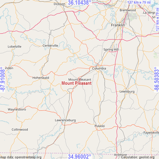
Mount Pleasant GPS coordinates[2]
35° 32' 3.264" North, 87° 12' 25.02" West
| Map corner | latitude | longitude |
|---|---|---|
| Upper-left | 36.10438°, | -87.91008° |
| Center: | 35.53424°, | -87.20695° |
| Lower-right: | 34.96002°, | -86.50383° |
| Map W x H: | 127.2×127.2 km | = 79×79mi |
| max Lat: | 71.29058° ⇑72.4% North |
| Mount Pleasant: | 35.53424° |
| min Lat: | ⇓27.6% South 19.06759° |
| min Long | Mount Pleasant | max Long |
| -171.73463° | -87.20695° | -66.98998° |
| W 49.8%⇐ | ⇒50.2% E |
Elevation
Elevation of Mount Pleasant is 205 m = 673 ft, and this is 89.8 m = 295 ft below average elevation for this country.
| Max E: |
3189 m = 10463 ft | 48.3% |
| Avg. | 294.8 m = 967 ft | |
| Mount Pleasant | 205 m = 673 ft | |
Min E: |
-60 m = -197 ft | 51.7% |
See also: United States elevation on elevation.city.
Geographical zone
Mount Pleasant is located in North temperate zone (between Tropic of Cancer and the Arctic Circle). Distance of this Northern Tropic circle is 1345.1 km =835.8 mi to South.| Distance of | km | miles | from Mount Pleasant |
|---|---|---|---|
| North Pole | 6056 | 3763 | to North |
| Arctic Circle | 3450.1 | 2143.8 | to North |
| Tropic Cancer | 1345.1 | 835.8 | to South |
| Equator | 3951 | 2455 | to South |


Nearby cities:
15 places around Mount Pleasant: (largest is in red/bold)
• Bon Aqua Junction
44.8 km =27.8 mi,  347°
347°
• Centerville
35.9 km =22.3 mi,  319°
319°
• Chapel Hill
47.6 km =29.6 mi,  77°
77°
• Columbia
17.9 km =11.1 mi,  59°
59°
• Cornersville
38.4 km =23.9 mi,  120°
120°
• Fairview
50.4 km =31.3 mi,  8°
8°
• Franklin
53.1 km =33 mi,  35°
35°
• Hohenwald
31.3 km =19.4 mi,  272°
272°
• Lawrenceburg
34.5 km =21.4 mi,  199°
199°
• Lewisburg
39 km =24.2 mi,  104°
104°
• Lyles
44.6 km =27.7 mi,  343°
343°
• Pulaski
40.5 km =25.2 mi,  156°
156°
• Spring Hill
34.8 km =21.6 mi,  46°
46°
• Summertown
14.6 km =9.1 mi,  220°
220°
• Thompson's Station
40 km =24.9 mi, 41°
Sources, notices
• [Note1] Compared only with cities in United States existing in our database
• [Src1] Map data: © OpenStreetMap contributors (CC-BY-SA)
• [Src2] Other city data from geonames.org with taken over terms of usage.
• [Src3] Geographical zone / Annual Mean Temperature by Robert A. Rohde @ Wikipedia
