Asherton geodata
Asherton (Texas) is a populated place; located in United States in America/Chicago (GMT-5) time zone. With population of 1,084 people, there are 15761 cities with bigger population in this country. Compared to other cities in United States, 96.1% of cities are located further ↑North; 80.5% of cities are located further →East and 58% of cities have higher elevation than Asherton. Note1


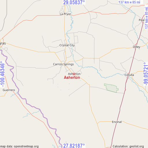
Asherton GPS coordinates[2]
28° 26' 30.948" North, 99° 45' 37.188" West
| Map corner | latitude | longitude |
|---|---|---|
| Upper-left | 29.05837°, | -100.46346° |
| Center: | 28.44193°, | -99.76033° |
| Lower-right: | 27.82187°, | -99.05721° |
| Map W x H: | 137.5×137.5 km | = 85.4×85.4mi |
| max Lat: | 71.29058° ⇑96.1% North |
| Asherton: | 28.44193° |
| min Lat: | ⇓3.9% South 19.06759° |
| min Long | Asherton | max Long |
| -171.73463° | -99.76033° | -66.98998° |
| W 19.5%⇐ | ⇒80.5% E |
Elevation
Elevation of Asherton is 165 m = 541 ft, and this is 129.8 m = 426 ft below average elevation for this country.
| Max E: |
3189 m = 10463 ft | 58% |
| Avg. | 294.8 m = 967 ft | |
| Asherton | 165 m = 541 ft | |
Min E: |
-60 m = -197 ft | 42% |
See also: United States elevation on elevation.city.
Geographical zone
Asherton is located in North temperate zone (between Tropic of Cancer and the Arctic Circle). Distance of this Northern Tropic circle is 556.5 km =345.8 mi to South.| Distance of | km | miles | from Asherton |
|---|---|---|---|
| North Pole | 6844.6 | 4253 | to North |
| Arctic Circle | 4238.7 | 2633.8 | to North |
| Tropic Cancer | 556.5 | 345.8 | to South |
| Equator | 3162.4 | 1965 | to South |


Nearby cities:
15 places around Asherton: (largest is in red/bold)
• Batesville
58.3 km =36.2 mi,  13°
13°
• Big Wells
23.8 km =14.8 mi,  52°
52°
• Cactus
69.5 km =43.2 mi,  148°
148°
• Carrizo Hill
9.6 km =6 mi,  315°
315°
• Carrizo Springs
13.2 km =8.2 mi,  312°
312°
• Cotulla
51.4 km =31.9 mi,  90°
90°
• Crystal City
27 km =16.8 mi,  345°
345°
• Dilley
62.8 km =39 mi,  66°
66°
• Encinal
59.7 km =37.1 mi,  138°
138°
• Gardendale
53.8 km =33.4 mi,  81°
81°
• La Pryor
56.2 km =34.9 mi, 351°
• Las Quintas Fronterizas
74.5 km =46.3 mi,  291°
291°
• Las Quintas Fronterizas Colonia
74.6 km =46.4 mi, 291°
• Rosita North
68.9 km =42.8 mi, 290°
• Rosita South
68.3 km =42.4 mi, 287°
Sources, notices
• [Note1] Compared only with cities in United States existing in our database
• [Src1] Map data: © OpenStreetMap contributors (CC-BY-SA)
• [Src2] Other city data from geonames.org with taken over terms of usage.
• [Src3] Geographical zone / Annual Mean Temperature by Robert A. Rohde @ Wikipedia
