Carrizo Hill geodata
Carrizo Hill (Texas) is a populated place; located in United States in America/Chicago (GMT-5) time zone. With population of 582 people, there are 19893 cities with bigger population in this country. Compared to other cities in United States, 96% of cities are located further ↑North; 80.6% of cities are located further →East and 52.2% of cities have higher elevation than Carrizo Hill. Note1


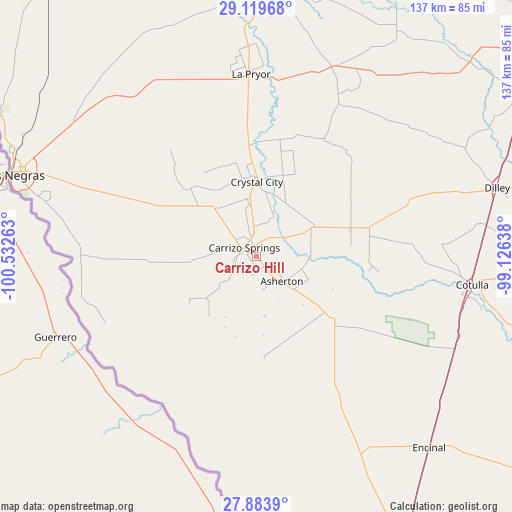
Carrizo Hill GPS coordinates[2]
28° 30' 12.96" North, 99° 49' 46.2" West
| Map corner | latitude | longitude |
|---|---|---|
| Upper-left | 29.11968°, | -100.53263° |
| Center: | 28.5036°, | -99.8295° |
| Lower-right: | 27.8839°, | -99.12638° |
| Map W x H: | 137.4×137.4 km | = 85.4×85.4mi |
| max Lat: | 71.29058° ⇑96% North |
| Carrizo Hill: | 28.5036° |
| min Lat: | ⇓4% South 19.06759° |
| min Long | Carrizo Hill | max Long |
| -171.73463° | -99.8295° | -66.98998° |
| W 19.4%⇐ | ⇒80.6% E |
Elevation
Elevation of Carrizo Hill is 190 m = 623 ft, and this is 104.8 m = 344 ft below average elevation for this country.
| Max E: |
3189 m = 10463 ft | 52.2% |
| Avg. | 294.8 m = 967 ft | |
| Carrizo Hill | 190 m = 623 ft | |
Min E: |
-60 m = -197 ft | 47.8% |
See also: United States elevation on elevation.city.
Geographical zone
Carrizo Hill is located in North temperate zone (between Tropic of Cancer and the Arctic Circle). Distance of this Northern Tropic circle is 563.4 km =350.1 mi to South.| Distance of | km | miles | from Carrizo Hill |
|---|---|---|---|
| North Pole | 6837.8 | 4248.8 | to North |
| Arctic Circle | 4231.9 | 2629.6 | to North |
| Tropic Cancer | 563.4 | 350.1 | to South |
| Equator | 3169.3 | 1969.3 | to South |


Nearby cities:
15 places around Carrizo Hill: (largest is in red/bold)
• Asherton
9.6 km =6 mi,  135°
135°
• Batesville
53.9 km =33.5 mi,  22°
22°
• Big Wells
26.6 km =16.5 mi,  73°
73°
• Carrizo Springs
3.7 km =2.3 mi,  303°
303°
• Cotulla
58.6 km =36.4 mi,  97°
97°
• Crystal City
19.3 km =12 mi,  0°
0°
• Dilley
66.9 km =41.6 mi, 74°
• Eidson Road
67 km =41.6 mi,  286°
286°
• Encinal
69.3 km =43.1 mi, 137°
• Gardendale
59.9 km =37.2 mi,  88°
88°
• La Pryor
48.7 km =30.3 mi,  357°
357°
• Las Quintas Fronterizas
65.8 km =40.9 mi, 288°
• Las Quintas Fronterizas Colonia
65.9 km =40.9 mi, 288°
• Rosita North
60.3 km =37.5 mi, 286°
• Rosita South
60 km =37.3 mi,  282°
282°
Sources, notices
• [Note1] Compared only with cities in United States existing in our database
• [Src1] Map data: © OpenStreetMap contributors (CC-BY-SA)
• [Src2] Other city data from geonames.org with taken over terms of usage.
• [Src3] Geographical zone / Annual Mean Temperature by Robert A. Rohde @ Wikipedia
