Big Wells geodata
Big Wells (Texas) is a populated place; located in United States in America/Chicago (GMT-5) time zone. With population of 762 people, there are 18109 cities with bigger population in this country. Compared to other cities in United States, 95.8% of cities are located further ↑North; 80.4% of cities are located further →East and 58.4% of cities have higher elevation than Big Wells. Note1


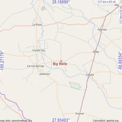
Big Wells GPS coordinates[2]
28° 34' 23.952" North, 99° 34' 7.176" West
| Map corner | latitude | longitude |
|---|---|---|
| Upper-left | 29.18899°, | -100.27179° |
| Center: | 28.57332°, | -99.56866° |
| Lower-right: | 27.95403°, | -98.86554° |
| Map W x H: | 137.3×137.3 km | = 85.3×85.3mi |
| max Lat: | 71.29058° ⇑95.8% North |
| Big Wells: | 28.57332° |
| min Lat: | ⇓4.2% South 19.06759° |
| min Long | Big Wells | max Long |
| -171.73463° | -99.56866° | -66.98998° |
| W 19.6%⇐ | ⇒80.4% E |
Elevation
Elevation of Big Wells is 163 m = 535 ft, and this is 131.8 m = 432 ft below average elevation for this country.
| Max E: |
3189 m = 10463 ft | 58.4% |
| Avg. | 294.8 m = 967 ft | |
| Big Wells | 163 m = 535 ft | |
Min E: |
-60 m = -197 ft | 41.6% |
See also: United States elevation on elevation.city.
Geographical zone
Big Wells is located in North temperate zone (between Tropic of Cancer and the Arctic Circle). Distance of this Northern Tropic circle is 571.1 km =354.9 mi to South.| Distance of | km | miles | from Big Wells |
|---|---|---|---|
| North Pole | 6830 | 4244 | to North |
| Arctic Circle | 4224.1 | 2624.7 | to North |
| Tropic Cancer | 571.1 | 354.9 | to South |
| Equator | 3177.1 | 1974.2 | to South |


Nearby cities:
15 places around Big Wells: (largest is in red/bold)
• Asherton
23.8 km =14.8 mi,  232°
232°
• Batesville
42.3 km =26.3 mi,  353°
353°
• Cactus
76 km =47.2 mi,  166°
166°
• Carrizo Hill
26.6 km =16.5 mi,  253°
253°
• Carrizo Springs
29.1 km =18.1 mi,  258°
258°
• Cotulla
36 km =22.4 mi,  114°
114°
• Crystal City
27.8 km =17.3 mi,  294°
294°
• Dilley
40.2 km =25 mi,  74°
74°
• Encinal
62.8 km =39 mi,  160°
160°
• Gardendale
35 km =21.7 mi,  100°
100°
• La Pryor
49.2 km =30.6 mi,  326°
326°
• North Pearsall
59.7 km =37.1 mi,  50°
50°
• Pearsall
58.2 km =36.2 mi, 52°
• Uvalde
73.9 km =45.9 mi,  343°
343°
• Uvalde Estates
70.6 km =43.9 mi, 338°
Sources, notices
• [Note1] Compared only with cities in United States existing in our database
• [Src1] Map data: © OpenStreetMap contributors (CC-BY-SA)
• [Src2] Other city data from geonames.org with taken over terms of usage.
• [Src3] Geographical zone / Annual Mean Temperature by Robert A. Rohde @ Wikipedia
