Carrizo Springs geodata
Carrizo Springs (Texas) is a seat of a second-order administrative division; located in United States in America/Chicago (GMT-5) time zone. With population of 5,898 people, there are 6472 cities with bigger population in this country. Compared to other cities in United States, 95.9% of cities are located further ↑North; 80.6% of cities are located further →East and 53.9% of cities have higher elevation than Carrizo Springs. Note1


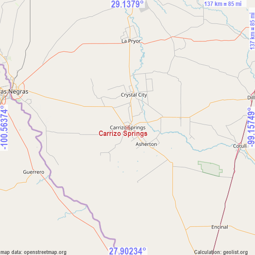
Carrizo Springs GPS coordinates[2]
28° 31' 18.948" North, 99° 51' 38.196" West
| Map corner | latitude | longitude |
|---|---|---|
| Upper-left | 29.1379°, | -100.56374° |
| Center: | 28.52193°, | -99.86061° |
| Lower-right: | 27.90234°, | -99.15749° |
| Map W x H: | 137.4×137.4 km | = 85.4×85.4mi |
| max Lat: | 71.29058° ⇑95.9% North |
| Carrizo Springs: | 28.52193° |
| min Lat: | ⇓4.1% South 19.06759° |
| min Long | Carrizo Springs | max Long |
| -171.73463° | -99.86061° | -66.98998° |
| W 19.4%⇐ | ⇒80.6% E |
Elevation
Elevation of Carrizo Springs is 184 m = 604 ft, and this is 110.8 m = 364 ft below average elevation for this country.
| Max E: |
3189 m = 10463 ft | 53.9% |
| Avg. | 294.8 m = 967 ft | |
| Carrizo Springs | 184 m = 604 ft | |
Min E: |
-60 m = -197 ft | 46.1% |
See also: United States elevation on elevation.city.
Geographical zone
Carrizo Springs is located in North temperate zone (between Tropic of Cancer and the Arctic Circle). Distance of this Northern Tropic circle is 565.4 km =351.3 mi to South.| Distance of | km | miles | from Carrizo Springs |
|---|---|---|---|
| North Pole | 6835.7 | 4247.5 | to North |
| Arctic Circle | 4229.8 | 2628.3 | to North |
| Tropic Cancer | 565.4 | 351.3 | to South |
| Equator | 3171.3 | 1970.6 | to South |


Nearby cities:
15 places around Carrizo Springs: (largest is in red/bold)
• Asherton
13.2 km =8.2 mi,  132°
132°
• Batesville
53.3 km =33.1 mi,  26°
26°
• Big Wells
29.1 km =18.1 mi,  78°
78°
• Carrizo Hill
3.7 km =2.3 mi,  123°
123°
• Cotulla
61.9 km =38.5 mi,  98°
98°
• Crystal City
17.6 km =10.9 mi,  10°
10°
• Eagle Pass
65.7 km =40.8 mi,  288°
288°
• Eidson Road
63.5 km =39.5 mi, 285°
• Gardendale
63 km =39.1 mi,  90°
90°
• La Pryor
46.6 km =29 mi,  1°
1°
• Las Quintas Fronterizas
62.2 km =38.6 mi, 287°
• Las Quintas Fronterizas Colonia
62.3 km =38.7 mi, 287°
• Rosita North
56.8 km =35.3 mi, 285°
• Rosita South
56.6 km =35.2 mi,  281°
281°
• Siesta Acres
66.8 km =41.5 mi, 293°
Sources, notices
• [Note1] Compared only with cities in United States existing in our database
• [Src1] Map data: © OpenStreetMap contributors (CC-BY-SA)
• [Src2] Other city data from geonames.org with taken over terms of usage.
• [Src3] Geographical zone / Annual Mean Temperature by Robert A. Rohde @ Wikipedia
