Tom Bean geodata
Tom Bean (Texas) is a populated place; located in United States in America/Chicago (GMT-5) time zone. With population of 1,055 people, there are 15926 cities with bigger population in this country. Compared to other cities in United States, 83% of cities are located further ↑North; 74.4% of cities are located further →East and 63.1% of cities have lower elevation than Tom Bean. Note1


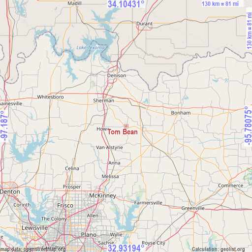
Tom Bean GPS coordinates[2]
33° 31' 12.396" North, 96° 29' 1.932" West
| Map corner | latitude | longitude |
|---|---|---|
| Upper-left | 34.10431°, | -97.187° |
| Center: | 33.52011°, | -96.48387° |
| Lower-right: | 32.93194°, | -95.78075° |
| Map W x H: | 130.4×130.4 km | = 81×81mi |
| max Lat: | 71.29058° ⇑83% North |
| Tom Bean: | 33.52011° |
| min Lat: | ⇓17% South 19.06759° |
| min Long | Tom Bean | max Long |
| -171.73463° | -96.48387° | -66.98998° |
| W 25.6%⇐ | ⇒74.4% E |
Elevation
Elevation of Tom Bean is 253 m = 830 ft, and this is 41.8 m = 137 ft below average elevation for this country.
| Max E: |
3189 m = 10463 ft | 36.9% |
| Avg. | 294.8 m = 967 ft | |
| Tom Bean | 253 m = 830 ft | |
Min E: |
-60 m = -197 ft | 63.1% |
See also: United States elevation on elevation.city.
Geographical zone
Tom Bean is located in North temperate zone (between Tropic of Cancer and the Arctic Circle). Distance of this Northern Tropic circle is 1121.2 km =696.7 mi to South.| Distance of | km | miles | from Tom Bean |
|---|---|---|---|
| North Pole | 6280 | 3902.2 | to North |
| Arctic Circle | 3674.1 | 2283 | to North |
| Tropic Cancer | 1121.2 | 696.7 | to South |
| Equator | 3727.1 | 2315.9 | to South |


Nearby cities:
15 places around Tom Bean: (largest is in red/bold)
• Anna
20 km =12.4 mi,  197°
197°
• Bells
12.1 km =7.5 mi,  33°
33°
• Blue Ridge
25.9 km =16.1 mi,  162°
162°
• Denison
26.6 km =16.5 mi,  349°
349°
• Ector
20.5 km =12.7 mi,  71°
71°
• Gunter
25.7 km =16 mi,  251°
251°
• Howe
12 km =7.5 mi,  263°
263°
• Leonard
26.9 km =16.7 mi,  125°
125°
• Luella
8.3 km =5.2 mi,  311°
311°
• Savoy
14 km =8.7 mi,  50°
50°
• Sherman
17.3 km =10.7 mi,  317°
317°
• Trenton
16.7 km =10.4 mi, 126°
• Van Alstyne
14 km =8.7 mi,  218°
218°
• Westminster
17.6 km =10.9 mi,  173°
173°
• Whitewright
8.5 km =5.3 mi,  95°
95°
Sources, notices
• [Note1] Compared only with cities in United States existing in our database
• [Src1] Map data: © OpenStreetMap contributors (CC-BY-SA)
• [Src2] Other city data from geonames.org with taken over terms of usage.
• [Src3] Geographical zone / Annual Mean Temperature by Robert A. Rohde @ Wikipedia
