Balch Springs geodata
Balch Springs (Texas) is a populated place; located in United States in America/Chicago (GMT-5) time zone. With population of 25,210 people, there are 1984 cities with bigger population in this country. Compared to other cities in United States, 86.3% of cities are located further ↑North; 74.8% of cities are located further →East and 59.1% of cities have higher elevation than Balch Springs. Note1


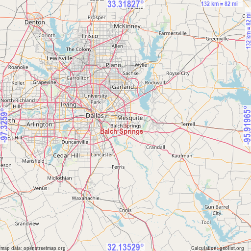
Balch Springs GPS coordinates[2]
32° 43' 43.464" North, 96° 37' 21.972" West
| Map corner | latitude | longitude |
|---|---|---|
| Upper-left | 33.31827°, | -97.3259° |
| Center: | 32.72874°, | -96.62277° |
| Lower-right: | 32.13529°, | -95.91965° |
| Map W x H: | 131.5×131.5 km | = 81.7×81.7mi |
| max Lat: | 71.29058° ⇑86.3% North |
| Balch Springs: | 32.72874° |
| min Lat: | ⇓13.7% South 19.06759° |
| min Long | Balch Springs | max Long |
| -171.73463° | -96.62277° | -66.98998° |
| W 25.2%⇐ | ⇒74.8% E |
Elevation
Elevation of Balch Springs is 159 m = 522 ft, and this is 135.8 m = 446 ft below average elevation for this country.
| Max E: |
3189 m = 10463 ft | 59.1% |
| Avg. | 294.8 m = 967 ft | |
| Balch Springs | 159 m = 522 ft | |
Min E: |
-60 m = -197 ft | 40.9% |
See also: United States elevation on elevation.city.
Geographical zone
Balch Springs is located in North temperate zone (between Tropic of Cancer and the Arctic Circle). Distance of this Northern Tropic circle is 1033.2 km =642 mi to South.| Distance of | km | miles | from Balch Springs |
|---|---|---|---|
| North Pole | 6368 | 3956.9 | to North |
| Arctic Circle | 3762.1 | 2337.7 | to North |
| Tropic Cancer | 1033.2 | 642 | to South |
| Equator | 3639.1 | 2261.2 | to South |


Nearby cities:
15 places around Balch Springs: (largest is in red/bold)
• Combine
18.9 km =11.7 mi,  145°
145°
• Crandall
19.2 km =11.9 mi,  125°
125°
• Dallas
18.2 km =11.3 mi,  289°
289°
• Forney
14.3 km =8.9 mi,  81°
81°
• Garland
20.5 km =12.7 mi,  355°
355°
• Heath
18.3 km =11.4 mi,  49°
49°
• Highland Park
19.6 km =12.2 mi,  306°
306°
• Hutchins
12.2 km =7.6 mi,  223°
223°
• Lancaster
19.7 km =12.2 mi, 219°
• Mesquite
4.8 km =3 mi,  27°
27°
• Rowlett
20.1 km =12.5 mi,  15°
15°
• Seagoville
12.7 km =7.9 mi,  141°
141°
• Sunnyvale
9.5 km =5.9 mi,  37°
37°
• Travis Ranch
16.3 km =10.1 mi,  59°
59°
• Wilmer
16.6 km =10.3 mi,  200°
200°
Sources, notices
• [Note1] Compared only with cities in United States existing in our database
• [Src1] Map data: © OpenStreetMap contributors (CC-BY-SA)
• [Src2] Other city data from geonames.org with taken over terms of usage.
• [Src3] Geographical zone / Annual Mean Temperature by Robert A. Rohde @ Wikipedia
