Highland Park geodata
Highland Park (Texas) is a populated place; located in United States in America/Chicago (GMT-5) time zone. With population of 9,189 people, there are 4741 cities with bigger population in this country. Compared to other cities in United States, 85.8% of cities are located further ↑North; 75.2% of cities are located further →East and 57.3% of cities have higher elevation than Highland Park. Note1


Highland Park GPS coordinates[2]
32° 50' 0.456" North, 96° 47' 31.02" West
| Map corner | latitude | longitude |
|---|---|---|
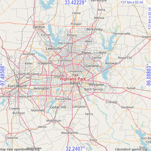
| Upper-left | 33.42229°, | -97.49508° |
| Center: | 32.83346°, | -96.79195° |
| Lower-right: | 32.2407°, | -96.08883° |
| Map W x H: | 131.4×131.4 km | = 81.6×81.6mi |
| max Lat: | 71.29058° ⇑85.8% North |
| Highland Park: | 32.83346° |
| min Lat: | ⇓14.2% South 19.06759° |
| min Long | Highland Park | max Long |
| -171.73463° | -96.79195° | -66.98998° |
| W 24.8%⇐ | ⇒75.2% E |
Elevation
Elevation of Highland Park is 169 m = 554 ft, and this is 125.8 m = 413 ft below average elevation for this country.
| Max E: |
3189 m = 10463 ft | 57.3% |
| Avg. | 294.8 m = 967 ft | |
| Highland Park | 169 m = 554 ft | |
Min E: |
-60 m = -197 ft | 42.7% |
See also: United States elevation on elevation.city.
Geographical zone
Highland Park is located in North temperate zone (between Tropic of Cancer and the Arctic Circle). Distance of this Northern Tropic circle is 1044.8 km =649.2 mi to South.| Distance of | km | miles | from Highland Park |
|---|---|---|---|
| North Pole | 6356.3 | 3949.6 | to North |
| Arctic Circle | 3750.4 | 2330.4 | to North |
| Tropic Cancer | 1044.8 | 649.2 | to South |
| Equator | 3650.7 | 2268.4 | to South |


Nearby cities:
15 places around Highland Park: (largest is in red/bold)
• Addison
14.7 km =9.1 mi,  346°
346°
• Balch Springs
19.6 km =12.2 mi,  126°
126°
• Carrollton
16.2 km =10.1 mi,  325°
325°
• Cockrell Hill
14 km =8.7 mi,  219°
219°
• Dallas
5.8 km =3.6 mi,  193°
193°
• Farmers Branch
14.2 km =8.8 mi,  316°
316°
• Garland
16.8 km =10.4 mi,  58°
58°
• Grand Prairie
21.6 km =13.4 mi,  243°
243°
• Hutchins
21.8 km =13.5 mi,  160°
160°
• Irving
14.8 km =9.2 mi,  261°
261°
• Mesquite
19.5 km =12.1 mi,  112°
112°
• Plano
22.5 km =14 mi,  22°
22°
• Richardson
14 km =8.7 mi, 24°
• Sunnyvale
22 km =13.7 mi,  100°
100°
• University Park
2 km =1.2 mi,  337°
337°
Sources, notices
• [Note1] Compared only with cities in United States existing in our database
• [Src1] Map data: © OpenStreetMap contributors (CC-BY-SA)
• [Src2] Other city data from geonames.org with taken over terms of usage.
• [Src3] Geographical zone / Annual Mean Temperature by Robert A. Rohde @ Wikipedia
