Mesquite geodata
Mesquite (Texas) is a populated place; located in United States in America/Chicago (GMT-5) time zone. With population of 144,788 people, there are 207 cities with bigger population in this country. Compared to other cities in United States, 86.1% of cities are located further ↑North; 74.7% of cities are located further →East and 59.9% of cities have higher elevation than Mesquite. Note1


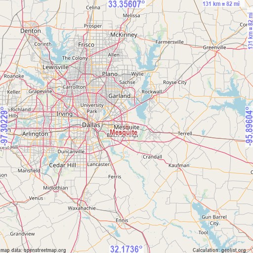
Mesquite GPS coordinates[2]
32° 46' 0.48" North, 96° 35' 56.976" West
| Map corner | latitude | longitude |
|---|---|---|
| Upper-left | 33.35607°, | -97.30229° |
| Center: | 32.7668°, | -96.59916° |
| Lower-right: | 32.1736°, | -95.89604° |
| Map W x H: | 131.5×131.5 km | = 81.7×81.7mi |
| max Lat: | 71.29058° ⇑86.1% North |
| Mesquite: | 32.7668° |
| min Lat: | ⇓13.9% South 19.06759° |
| min Long | Mesquite | max Long |
| -171.73463° | -96.59916° | -66.98998° |
| W 25.3%⇐ | ⇒74.7% E |
Elevation
Elevation of Mesquite is 155 m = 509 ft, and this is 139.8 m = 459 ft below average elevation for this country.
| Max E: |
3189 m = 10463 ft | 59.9% |
| Avg. | 294.8 m = 967 ft | |
| Mesquite | 155 m = 509 ft | |
Min E: |
-60 m = -197 ft | 40.1% |
See also: Mesquite elevation on elevation.city.
Geographical zone
Mesquite is located in North temperate zone (between Tropic of Cancer and the Arctic Circle). Distance of this Northern Tropic circle is 1037.4 km =644.6 mi to South.| Distance of | km | miles | from Mesquite |
|---|---|---|---|
| North Pole | 6363.7 | 3954.2 | to North |
| Arctic Circle | 3757.8 | 2335 | to North |
| Tropic Cancer | 1037.4 | 644.6 | to South |
| Equator | 3643.3 | 2263.8 | to South |


Nearby cities:
15 places around Mesquite: (largest is in red/bold)
• Balch Springs
4.8 km =3 mi,  207°
207°
• Combine
21.6 km =13.4 mi,  156°
156°
• Crandall
20.5 km =12.7 mi,  139°
139°
• Dallas
19.5 km =12.1 mi,  275°
275°
• Forney
12.1 km =7.5 mi,  99°
99°
• Garland
16.6 km =10.3 mi,  347°
347°
• Heath
14 km =8.7 mi,  56°
56°
• Highland Park
19.5 km =12.1 mi,  292°
292°
• Hutchins
16.9 km =10.5 mi,  219°
219°
• Rowlett
15.5 km =9.6 mi,  12°
12°
• Seagoville
15.2 km =9.4 mi, 158°
• Sunnyvale
4.9 km =3 mi,  47°
47°
• Travis Ranch
12.4 km =7.7 mi,  70°
70°
• University Park
21 km =13 mi,  296°
296°
• Wilmer
21.3 km =13.2 mi,  202°
202°
Sources, notices
• [Note1] Compared only with cities in United States existing in our database
• [Src1] Map data: © OpenStreetMap contributors (CC-BY-SA)
• [Src2] Other city data from geonames.org with taken over terms of usage.
• [Src3] Geographical zone / Annual Mean Temperature by Robert A. Rohde @ Wikipedia
