Sunnyvale geodata
Sunnyvale (Texas) is a populated place; located in United States in America/Chicago (GMT-5) time zone. With population of 6,044 people, there are 6370 cities with bigger population in this country. Compared to other cities in United States, 86% of cities are located further ↑North; 74.6% of cities are located further →East and 60.5% of cities have higher elevation than Sunnyvale. Note1


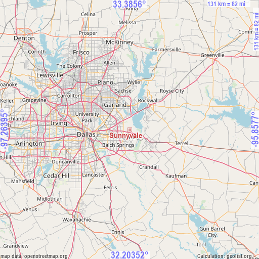
Sunnyvale GPS coordinates[2]
32° 47' 47.472" North, 96° 33' 38.952" West
| Map corner | latitude | longitude |
|---|---|---|
| Upper-left | 33.3856°, | -97.26395° |
| Center: | 32.79652°, | -96.56082° |
| Lower-right: | 32.20352°, | -95.8577° |
| Map W x H: | 131.4×131.4 km | = 81.6×81.6mi |
| max Lat: | 71.29058° ⇑86% North |
| Sunnyvale: | 32.79652° |
| min Lat: | ⇓14% South 19.06759° |
| min Long | Sunnyvale | max Long |
| -171.73463° | -96.56082° | -66.98998° |
| W 25.4%⇐ | ⇒74.6% E |
Elevation
Elevation of Sunnyvale is 152 m = 499 ft, and this is 142.8 m = 469 ft below average elevation for this country.
| Max E: |
3189 m = 10463 ft | 60.5% |
| Avg. | 294.8 m = 967 ft | |
| Sunnyvale | 152 m = 499 ft | |
Min E: |
-60 m = -197 ft | 39.5% |
See also: United States elevation on elevation.city.
Geographical zone
Sunnyvale is located in North temperate zone (between Tropic of Cancer and the Arctic Circle). Distance of this Northern Tropic circle is 1040.7 km =646.7 mi to South.| Distance of | km | miles | from Sunnyvale |
|---|---|---|---|
| North Pole | 6360.4 | 3952.2 | to North |
| Arctic Circle | 3754.5 | 2332.9 | to North |
| Tropic Cancer | 1040.7 | 646.7 | to South |
| Equator | 3646.6 | 2265.9 | to South |


Nearby cities:
15 places around Sunnyvale: (largest is in red/bold)
• Balch Springs
9.5 km =5.9 mi,  217°
217°
• Crandall
21.2 km =13.2 mi,  152°
152°
• Forney
9.9 km =6.2 mi,  122°
122°
• Garland
14.8 km =9.2 mi,  330°
330°
• Heath
9.2 km =5.7 mi,  60°
60°
• Highland Park
22 km =13.7 mi,  280°
280°
• Hutchins
21.7 km =13.5 mi, 221°
• McLendon-Chisholm
17.6 km =10.9 mi,  73°
73°
• Mesquite
4.9 km =3 mi,  227°
227°
• Rockwall
17.7 km =11 mi,  32°
32°
• Rowlett
11.8 km =7.3 mi,  358°
358°
• Sachse
20.2 km =12.6 mi,  350°
350°
• Seagoville
17.6 km =10.9 mi,  173°
173°
• Talty
20.7 km =12.9 mi,  127°
127°
• Travis Ranch
8.2 km =5.1 mi,  84°
84°
Sources, notices
• [Note1] Compared only with cities in United States existing in our database
• [Src1] Map data: © OpenStreetMap contributors (CC-BY-SA)
• [Src2] Other city data from geonames.org with taken over terms of usage.
• [Src3] Geographical zone / Annual Mean Temperature by Robert A. Rohde @ Wikipedia
