George West geodata
George West (Texas) is a seat of a second-order administrative division; located in United States in America/Chicago (GMT-5) time zone. With population of 2,631 people, there are 10326 cities with bigger population in this country. Compared to other cities in United States, 96.2% of cities are located further ↑North; 78.8% of cities are located further →East and 79% of cities have higher elevation than George West. Note1


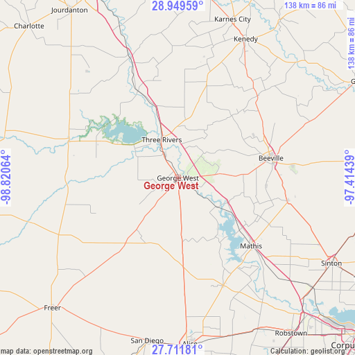
George West GPS coordinates[2]
28° 19' 57" North, 98° 7' 3.036" West
| Map corner | latitude | longitude |
|---|---|---|
| Upper-left | 28.94959°, | -98.82064° |
| Center: | 28.3325°, | -98.11751° |
| Lower-right: | 27.71181°, | -97.41439° |
| Map W x H: | 137.6×137.6 km | = 85.5×85.5mi |
| max Lat: | 71.29058° ⇑96.2% North |
| George West: | 28.3325° |
| min Lat: | ⇓3.8% South 19.06759° |
| min Long | George West | max Long |
| -171.73463° | -98.11751° | -66.98998° |
| W 21.2%⇐ | ⇒78.8% E |
Elevation
Elevation of George West is 51 m = 167 ft, and this is 243.8 m = 800 ft below average elevation for this country.
| Max E: |
3189 m = 10463 ft | 79% |
| Avg. | 294.8 m = 967 ft | |
| George West | 51 m = 167 ft | |
Min E: |
-60 m = -197 ft | 21% |
See also: United States elevation on elevation.city.
Geographical zone
George West is located in North temperate zone (between Tropic of Cancer and the Arctic Circle). Distance of this Northern Tropic circle is 544.4 km =338.3 mi to South.| Distance of | km | miles | from George West |
|---|---|---|---|
| North Pole | 6856.8 | 4260.6 | to North |
| Arctic Circle | 4250.9 | 2641.4 | to North |
| Tropic Cancer | 544.4 | 338.3 | to South |
| Equator | 3150.3 | 1957.5 | to South |


Nearby cities:
15 places around George West: (largest is in red/bold)
• Agua Dulce
64.6 km =40.1 mi,  161°
161°
• Alice
64.7 km =40.2 mi,  175°
175°
• Beeville
36.8 km =22.9 mi,  78°
78°
• Blue Berry Hill
33.4 km =20.8 mi, 79°
• Kenedy
60.1 km =37.3 mi,  25°
25°
• Lake City
36.2 km =22.5 mi,  141°
141°
• Lakeshore Gardens-Hidden Acres
34.1 km =21.2 mi,  132°
132°
• Mathis
38.8 km =24.1 mi, 133°
• Orange Grove
45.4 km =28.2 mi, 157°
• Pettus
44.2 km =27.5 mi,  44°
44°
• Saint Paul
60.8 km =37.8 mi,  115°
115°
• San Diego
64.3 km =40 mi,  190°
190°
• Skidmore
43.2 km =26.8 mi,  101°
101°
• Three Rivers
15.6 km =9.7 mi,  335°
335°
• Tilden
44.6 km =27.7 mi,  288°
288°
Sources, notices
• [Note1] Compared only with cities in United States existing in our database
• [Src1] Map data: © OpenStreetMap contributors (CC-BY-SA)
• [Src2] Other city data from geonames.org with taken over terms of usage.
• [Src3] Geographical zone / Annual Mean Temperature by Robert A. Rohde @ Wikipedia
