Bogata geodata
Bogata (Texas) is a populated place; located in United States in America/Chicago (GMT-5) time zone. With population of 1,111 people, there are 15610 cities with bigger population in this country. Compared to other cities in United States, 83.3% of cities are located further ↑North; 71.6% of cities are located further →East and 63.8% of cities have higher elevation than Bogata. Note1


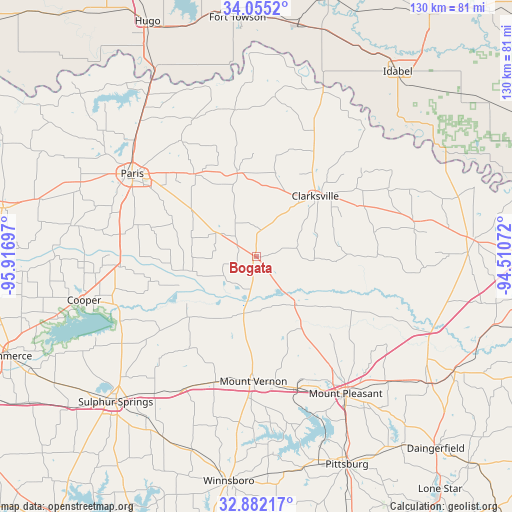
Bogata GPS coordinates[2]
33° 28' 14.412" North, 95° 12' 49.824" West
| Map corner | latitude | longitude |
|---|---|---|
| Upper-left | 34.0552°, | -95.91697° |
| Center: | 33.47067°, | -95.21384° |
| Lower-right: | 32.88217°, | -94.51072° |
| Map W x H: | 130.4×130.4 km | = 81×81mi |
| max Lat: | 71.29058° ⇑83.3% North |
| Bogata: | 33.47067° |
| min Lat: | ⇓16.7% South 19.06759° |
| min Long | Bogata | max Long |
| -171.73463° | -95.21384° | -66.98998° |
| W 28.4%⇐ | ⇒71.6% E |
Elevation
Elevation of Bogata is 134 m = 440 ft, and this is 160.8 m = 528 ft below average elevation for this country.
| Max E: |
3189 m = 10463 ft | 63.8% |
| Avg. | 294.8 m = 967 ft | |
| Bogata | 134 m = 440 ft | |
Min E: |
-60 m = -197 ft | 36.2% |
See also: United States elevation on elevation.city.
Geographical zone
Bogata is located in North temperate zone (between Tropic of Cancer and the Arctic Circle). Distance of this Northern Tropic circle is 1115.7 km =693.3 mi to South.| Distance of | km | miles | from Bogata |
|---|---|---|---|
| North Pole | 6285.5 | 3905.6 | to North |
| Arctic Circle | 3679.6 | 2286.4 | to North |
| Tropic Cancer | 1115.7 | 693.3 | to South |
| Equator | 3721.6 | 2312.5 | to South |


Nearby cities:
15 places around Bogata: (largest is in red/bold)
• Blossom
26.5 km =16.5 mi,  323°
323°
• Clarksville
21.6 km =13.4 mi,  43°
43°
• Cooper
45.3 km =28.1 mi,  256°
256°
• Deport
11.3 km =7 mi,  303°
303°
• Detroit
21.8 km =13.5 mi,  347°
347°
• Lone Star
38.5 km =23.9 mi,  335°
335°
• Mount Pleasant
41.7 km =25.9 mi,  146°
146°
• Mount Vernon
31.4 km =19.5 mi,  181°
181°
• Paris
38.1 km =23.7 mi, 303°
• Pine Forest
42.9 km =26.7 mi,  201°
201°
• Powderly
47.5 km =29.5 mi, 322°
• Reno
31.4 km =19.5 mi,  312°
312°
• Roxton
48.2 km =30 mi,  280°
280°
• Talco
15.7 km =9.8 mi,  139°
139°
• Winfield
35 km =21.7 mi,  164°
164°
Sources, notices
• [Note1] Compared only with cities in United States existing in our database
• [Src1] Map data: © OpenStreetMap contributors (CC-BY-SA)
• [Src2] Other city data from geonames.org with taken over terms of usage.
• [Src3] Geographical zone / Annual Mean Temperature by Robert A. Rohde @ Wikipedia
