Deport geodata
Deport (Texas) is a populated place; located in United States in America/Chicago (GMT-5) time zone. With population of 566 people, there are 20074 cities with bigger population in this country. Compared to other cities in United States, 83% of cities are located further ↑North; 71.9% of cities are located further →East and 64.4% of cities have higher elevation than Deport. Note1


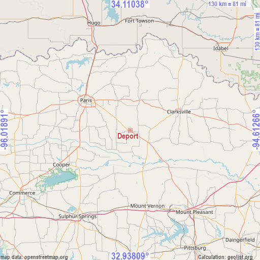
Deport GPS coordinates[2]
33° 31' 34.392" North, 95° 18' 56.808" West
| Map corner | latitude | longitude |
|---|---|---|
| Upper-left | 34.11038°, | -96.01891° |
| Center: | 33.52622°, | -95.31578° |
| Lower-right: | 32.93809°, | -94.61266° |
| Map W x H: | 130.3×130.3 km | = 81×81mi |
| max Lat: | 71.29058° ⇑83% North |
| Deport: | 33.52622° |
| min Lat: | ⇓17% South 19.06759° |
| min Long | Deport | max Long |
| -171.73463° | -95.31578° | -66.98998° |
| W 28.1%⇐ | ⇒71.9% E |
Elevation
Elevation of Deport is 131 m = 430 ft, and this is 163.8 m = 537 ft below average elevation for this country.
| Max E: |
3189 m = 10463 ft | 64.4% |
| Avg. | 294.8 m = 967 ft | |
| Deport | 131 m = 430 ft | |
Min E: |
-60 m = -197 ft | 35.6% |
See also: United States elevation on elevation.city.
Geographical zone
Deport is located in North temperate zone (between Tropic of Cancer and the Arctic Circle). Distance of this Northern Tropic circle is 1121.8 km =697.1 mi to South.| Distance of | km | miles | from Deport |
|---|---|---|---|
| North Pole | 6279.3 | 3901.8 | to North |
| Arctic Circle | 3673.4 | 2282.5 | to North |
| Tropic Cancer | 1121.8 | 697.1 | to South |
| Equator | 3727.8 | 2316.3 | to South |


Nearby cities:
15 places around Deport: (largest is in red/bold)
• Blossom
16.4 km =10.2 mi,  336°
336°
• Bogata
11.3 km =7 mi,  123°
123°
• Clarksville
26.1 km =16.2 mi,  68°
68°
• Cooper
38.5 km =23.9 mi,  243°
243°
• Detroit
15.7 km =9.8 mi,  16°
16°
• Lone Star
29.6 km =18.4 mi,  347°
347°
• Mount Vernon
38.5 km =23.9 mi,  166°
166°
• Paris
26.8 km =16.7 mi,  304°
304°
• Pine Forest
46.4 km =28.8 mi,  187°
187°
• Powderly
37.1 km =23.1 mi,  328°
328°
• Reno
20.4 km =12.7 mi,  318°
318°
• Roxton
38.1 km =23.7 mi,  273°
273°
• Sulphur Springs
50.6 km =31.4 mi,  211°
211°
• Talco
26.7 km =16.6 mi,  132°
132°
• Winfield
44.2 km =27.5 mi,  154°
154°
Sources, notices
• [Note1] Compared only with cities in United States existing in our database
• [Src1] Map data: © OpenStreetMap contributors (CC-BY-SA)
• [Src2] Other city data from geonames.org with taken over terms of usage.
• [Src3] Geographical zone / Annual Mean Temperature by Robert A. Rohde @ Wikipedia
