Roxton geodata
Roxton (Texas) is a populated place; located in United States in America/Chicago (GMT-5) time zone. With population of 642 people, there are 19249 cities with bigger population in this country. Compared to other cities in United States, 82.9% of cities are located further ↑North; 72.9% of cities are located further →East and 58.6% of cities have higher elevation than Roxton. Note1


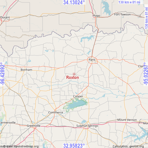
Roxton GPS coordinates[2]
33° 32' 46.392" North, 95° 43' 32.844" West
| Map corner | latitude | longitude |
|---|---|---|
| Upper-left | 34.13024°, | -96.42892° |
| Center: | 33.54622°, | -95.72579° |
| Lower-right: | 32.95823°, | -95.02267° |
| Map W x H: | 130.3×130.3 km | = 81×81mi |
| max Lat: | 71.29058° ⇑82.9% North |
| Roxton: | 33.54622° |
| min Lat: | ⇓17.1% South 19.06759° |
| min Long | Roxton | max Long |
| -171.73463° | -95.72579° | -66.98998° |
| W 27.1%⇐ | ⇒72.9% E |
Elevation
Elevation of Roxton is 162 m = 531 ft, and this is 132.8 m = 436 ft below average elevation for this country.
| Max E: |
3189 m = 10463 ft | 58.6% |
| Avg. | 294.8 m = 967 ft | |
| Roxton | 162 m = 531 ft | |
Min E: |
-60 m = -197 ft | 41.4% |
See also: United States elevation on elevation.city.
Geographical zone
Roxton is located in North temperate zone (between Tropic of Cancer and the Arctic Circle). Distance of this Northern Tropic circle is 1124.1 km =698.5 mi to South.| Distance of | km | miles | from Roxton |
|---|---|---|---|
| North Pole | 6277.1 | 3900.4 | to North |
| Arctic Circle | 3671.2 | 2281.2 | to North |
| Tropic Cancer | 1124.1 | 698.5 | to South |
| Equator | 3730 | 2317.7 | to South |


Nearby cities:
15 places around Roxton: (largest is in red/bold)
• Blossom
34 km =21.1 mi,  67°
67°
• Bonham
42.1 km =26.2 mi,  274°
274°
• Commerce
37 km =23 mi,  205°
205°
• Cooper
19.5 km =12.1 mi,  169°
169°
• Cumby
46.7 km =29 mi,  193°
193°
• Deport
38.1 km =23.7 mi,  93°
93°
• Detroit
44.4 km =27.6 mi, 73°
• Honey Grove
17.6 km =10.9 mi,  283°
283°
• Ladonia
24.5 km =15.2 mi,  236°
236°
• Lone Star
41.1 km =25.5 mi,  49°
49°
• Paris
20.3 km =12.6 mi, 51°
• Powderly
34.9 km =21.7 mi,  32°
32°
• Reno
27.6 km =17.1 mi,  61°
61°
• Sulphur Springs
46.8 km =29.1 mi, 165°
• Wolfe City
37.3 km =23.2 mi, 238°
Sources, notices
• [Note1] Compared only with cities in United States existing in our database
• [Src1] Map data: © OpenStreetMap contributors (CC-BY-SA)
• [Src2] Other city data from geonames.org with taken over terms of usage.
• [Src3] Geographical zone / Annual Mean Temperature by Robert A. Rohde @ Wikipedia
