Bowie geodata
Bowie (Texas) is a populated place; located in United States in America/Chicago (GMT-5) time zone. With population of 5,126 people, there are 7057 cities with bigger population in this country. Compared to other cities in United States, 82.8% of cities are located further ↑North; 78.1% of cities are located further →East and 79.7% of cities have lower elevation than Bowie. Note1


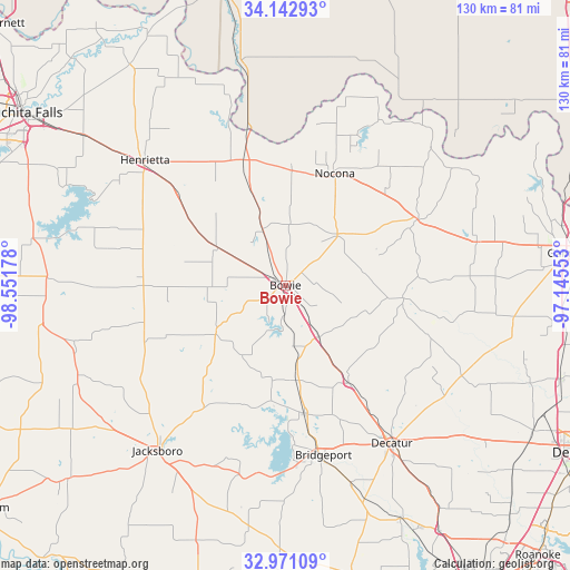
Bowie GPS coordinates[2]
33° 33' 32.4" North, 97° 50' 55.14" West
| Map corner | latitude | longitude |
|---|---|---|
| Upper-left | 34.14293°, | -98.55178° |
| Center: | 33.559°, | -97.84865° |
| Lower-right: | 32.97109°, | -97.14553° |
| Map W x H: | 130.3×130.3 km | = 81×81mi |
| max Lat: | 71.29058° ⇑82.8% North |
| Bowie: | 33.559° |
| min Lat: | ⇓17.2% South 19.06759° |
| min Long | Bowie | max Long |
| -171.73463° | -97.84865° | -66.98998° |
| W 21.9%⇐ | ⇒78.1% E |
Elevation
Elevation of Bowie is 350 m = 1148 ft, and this is 55.2 m = 181 ft above average elevation for this country.
| Max E: |
3189 m = 10463 ft | 20.3% |
| Bowie | 350 m 1148 ft | |
| Avg. | 294.8 m = 967 ft | |
Min E: |
-60 m = -197 ft | 79.7% |
See also: United States elevation on elevation.city.
Geographical zone
Bowie is located in North temperate zone (between Tropic of Cancer and the Arctic Circle). Distance of this Northern Tropic circle is 1125.5 km =699.4 mi to South.| Distance of | km | miles | from Bowie |
|---|---|---|---|
| North Pole | 6275.7 | 3899.5 | to North |
| Arctic Circle | 3669.8 | 2280.3 | to North |
| Tropic Cancer | 1125.5 | 699.4 | to South |
| Equator | 3731.4 | 2318.6 | to South |


Nearby cities:
15 places around Bowie: (largest is in red/bold)
• Alvord
26.5 km =16.5 mi,  147°
147°
• Boyd
59.5 km =37 mi, 153°
• Bridgeport
39.8 km =24.7 mi,  167°
167°
• Chico
29.6 km =18.4 mi, 171°
• Decatur
43.6 km =27.1 mi, 145°
• Henrietta
43.1 km =26.8 mi,  311°
311°
• Jacksboro
47.6 km =29.6 mi,  217°
217°
• Lindsay
58.6 km =36.4 mi,  81°
81°
• Montague
16.7 km =10.4 mi,  45°
45°
• Muenster
44.9 km =27.9 mi, 76°
• Nocona
27.8 km =17.3 mi,  24°
24°
• Nocona Hills
37.4 km =23.2 mi,  29°
29°
• Runaway Bay
43.6 km =27.1 mi,  183°
183°
• Ryan
52.2 km =32.4 mi,  348°
348°
• Saint Jo
33.8 km =21 mi,  63°
63°
Sources, notices
• [Note1] Compared only with cities in United States existing in our database
• [Src1] Map data: © OpenStreetMap contributors (CC-BY-SA)
• [Src2] Other city data from geonames.org with taken over terms of usage.
• [Src3] Geographical zone / Annual Mean Temperature by Robert A. Rohde @ Wikipedia
