Muenster geodata
Muenster (Texas) is a populated place; located in United States in America/Chicago (GMT-5) time zone. With population of 1,608 people, there are 13272 cities with bigger population in this country. Compared to other cities in United States, 82.4% of cities are located further ↑North; 76.8% of cities are located further →East and 74.2% of cities have lower elevation than Muenster. Note1


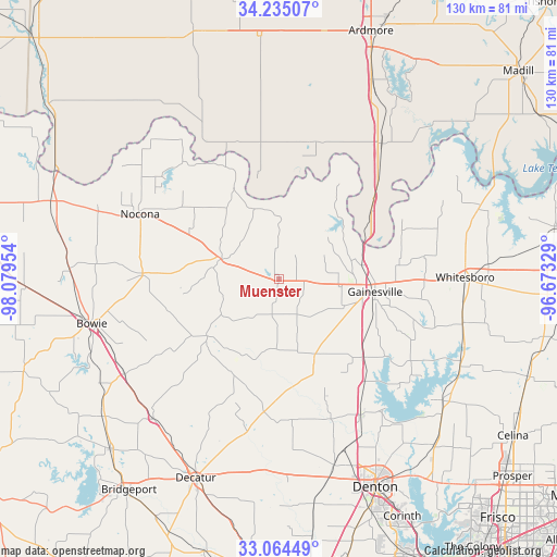
Muenster GPS coordinates[2]
33° 39' 6.372" North, 97° 22' 35.076" West
| Map corner | latitude | longitude |
|---|---|---|
| Upper-left | 34.23507°, | -98.07954° |
| Center: | 33.65177°, | -97.37641° |
| Lower-right: | 33.06449°, | -96.67329° |
| Map W x H: | 130.2×130.2 km | = 80.9×80.9mi |
| max Lat: | 71.29058° ⇑82.4% North |
| Muenster: | 33.65177° |
| min Lat: | ⇓17.6% South 19.06759° |
| min Long | Muenster | max Long |
| -171.73463° | -97.37641° | -66.98998° |
| W 23.2%⇐ | ⇒76.8% E |
Elevation
Elevation of Muenster is 308 m = 1010 ft, and this is 13.2 m = 43 ft above average elevation for this country.
| Max E: |
3189 m = 10463 ft | 25.8% |
| Muenster | 308 m 1010 ft | |
| Avg. | 294.8 m = 967 ft | |
Min E: |
-60 m = -197 ft | 74.2% |
See also: United States elevation on elevation.city.
Geographical zone
Muenster is located in North temperate zone (between Tropic of Cancer and the Arctic Circle). Distance of this Northern Tropic circle is 1135.8 km =705.8 mi to South.| Distance of | km | miles | from Muenster |
|---|---|---|---|
| North Pole | 6265.3 | 3893.1 | to North |
| Arctic Circle | 3659.4 | 2273.8 | to North |
| Tropic Cancer | 1135.8 | 705.8 | to South |
| Equator | 3741.7 | 2325 | to South |


Nearby cities:
15 places around Muenster: (largest is in red/bold)
• Alvord
44 km =27.3 mi,  222°
222°
• Bowie
44.9 km =27.9 mi,  256°
256°
• Collinsville
44.2 km =27.5 mi,  103°
103°
• Gainesville
22.7 km =14.1 mi, 97°
• Krum
45.3 km =28.1 mi,  163°
163°
• Lake Kiowa
34.7 km =21.6 mi, 103°
• Lindsay
14.3 km =8.9 mi, 97°
• Marietta
39.8 km =24.7 mi,  37°
37°
• Montague
31.9 km =19.8 mi,  272°
272°
• Nocona
35.6 km =22.1 mi,  294°
294°
• Nocona Hills
33.7 km =20.9 mi,  311°
311°
• Saint Jo
14.3 km =8.9 mi, 289°
• Sanger
37.2 km =23.1 mi,  149°
149°
• Valley View
26.7 km =16.6 mi,  132°
132°
• Whitesboro
43.5 km =27 mi,  89°
89°
Sources, notices
• [Note1] Compared only with cities in United States existing in our database
• [Src1] Map data: © OpenStreetMap contributors (CC-BY-SA)
• [Src2] Other city data from geonames.org with taken over terms of usage.
• [Src3] Geographical zone / Annual Mean Temperature by Robert A. Rohde @ Wikipedia
