Jacksboro geodata
Jacksboro (Texas) is a seat of a second-order administrative division; located in United States in America/Chicago (GMT-5) time zone. With population of 4,424 people, there are 7721 cities with bigger population in this country. Compared to other cities in United States, 84.3% of cities are located further ↑North; 78.8% of cities are located further →East and 78% of cities have lower elevation than Jacksboro. Note1


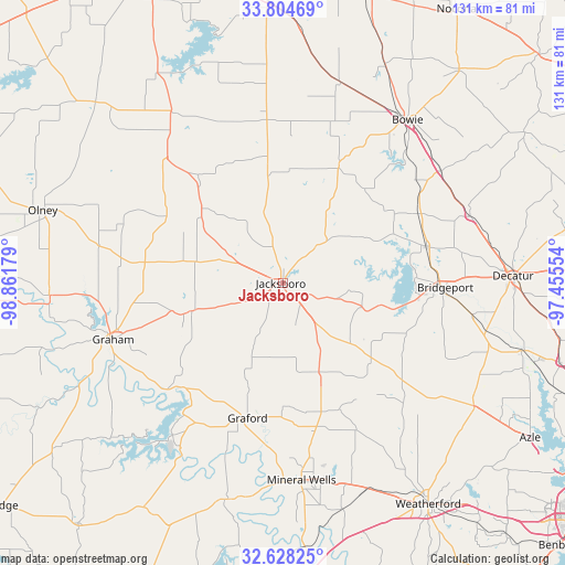
Jacksboro GPS coordinates[2]
33° 13' 6.42" North, 98° 9' 31.176" West
| Map corner | latitude | longitude |
|---|---|---|
| Upper-left | 33.80469°, | -98.86179° |
| Center: | 33.21845°, | -98.15866° |
| Lower-right: | 32.62825°, | -97.45554° |
| Map W x H: | 130.8×130.8 km | = 81.3×81.3mi |
| max Lat: | 71.29058° ⇑84.3% North |
| Jacksboro: | 33.21845° |
| min Lat: | ⇓15.7% South 19.06759° |
| min Long | Jacksboro | max Long |
| -171.73463° | -98.15866° | -66.98998° |
| W 21.2%⇐ | ⇒78.8% E |
Elevation
Elevation of Jacksboro is 336 m = 1102 ft, and this is 41.2 m = 135 ft above average elevation for this country.
| Max E: |
3189 m = 10463 ft | 22% |
| Jacksboro | 336 m 1102 ft | |
| Avg. | 294.8 m = 967 ft | |
Min E: |
-60 m = -197 ft | 78% |
See also: United States elevation on elevation.city.
Geographical zone
Jacksboro is located in North temperate zone (between Tropic of Cancer and the Arctic Circle). Distance of this Northern Tropic circle is 1087.6 km =675.8 mi to South.| Distance of | km | miles | from Jacksboro |
|---|---|---|---|
| North Pole | 6313.5 | 3923 | to North |
| Arctic Circle | 3707.6 | 2303.8 | to North |
| Tropic Cancer | 1087.6 | 675.8 | to South |
| Equator | 3693.5 | 2295 | to South |


Nearby cities:
15 places around Jacksboro: (largest is in red/bold)
• Alvord
45.8 km =28.5 mi,  70°
70°
• Bowie
47.6 km =29.6 mi,  37°
37°
• Boyd
57.4 km =35.7 mi,  105°
105°
• Bridgeport
37.6 km =23.4 mi,  91°
91°
• Bryson
22.1 km =13.7 mi,  253°
253°
• Chico
34.5 km =21.4 mi,  75°
75°
• Decatur
53.3 km =33.1 mi, 88°
• Graford
32.3 km =20.1 mi,  194°
194°
• Graham
42 km =26.1 mi, 252°
• Mineral Wells
45.8 km =28.5 mi,  174°
174°
• Newcastle
54 km =33.6 mi,  267°
267°
• Olney
57.8 km =35.9 mi,  287°
287°
• Palo Pinto
51.8 km =32.2 mi, 194°
• Runaway Bay
26.7 km =16.6 mi,  102°
102°
• Springtown
52.4 km =32.6 mi,  122°
122°
Sources, notices
• [Note1] Compared only with cities in United States existing in our database
• [Src1] Map data: © OpenStreetMap contributors (CC-BY-SA)
• [Src2] Other city data from geonames.org with taken over terms of usage.
• [Src3] Geographical zone / Annual Mean Temperature by Robert A. Rohde @ Wikipedia
