Clifton geodata
Clifton (Texas) is a populated place; located in United States in America/Chicago (GMT-5) time zone. With population of 3,361 people, there are 9050 cities with bigger population in this country. Compared to other cities in United States, 89% of cities are located further ↑North; 77.3% of cities are located further →East and 52.8% of cities have lower elevation than Clifton. Note1


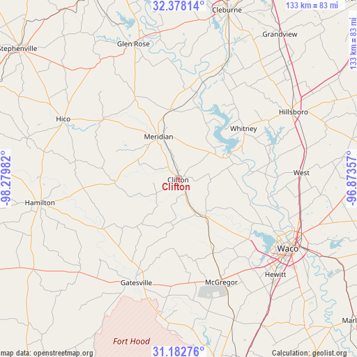
Clifton GPS coordinates[2]
31° 46' 56.568" North, 97° 34' 36.084" West
| Map corner | latitude | longitude |
|---|---|---|
| Upper-left | 32.37814°, | -98.27982° |
| Center: | 31.78238°, | -97.57669° |
| Lower-right: | 31.18276°, | -96.87357° |
| Map W x H: | 132.9×132.9 km | = 82.6×82.6mi |
| max Lat: | 71.29058° ⇑89% North |
| Clifton: | 31.78238° |
| min Lat: | ⇓11% South 19.06759° |
| min Long | Clifton | max Long |
| -171.73463° | -97.57669° | -66.98998° |
| W 22.7%⇐ | ⇒77.3% E |
Elevation
Elevation of Clifton is 209 m = 686 ft, and this is 85.8 m = 281 ft below average elevation for this country.
| Max E: |
3189 m = 10463 ft | 47.2% |
| Avg. | 294.8 m = 967 ft | |
| Clifton | 209 m = 686 ft | |
Min E: |
-60 m = -197 ft | 52.8% |
See also: United States elevation on elevation.city.
Geographical zone
Clifton is located in North temperate zone (between Tropic of Cancer and the Arctic Circle). Distance of this Northern Tropic circle is 928 km =576.6 mi to South.| Distance of | km | miles | from Clifton |
|---|---|---|---|
| North Pole | 6473.2 | 4022.3 | to North |
| Arctic Circle | 3867.3 | 2403 | to North |
| Tropic Cancer | 928 | 576.6 | to South |
| Equator | 3533.9 | 2195.9 | to South |


Nearby cities:
15 places around Clifton: (largest is in red/bold)
• Ames
34.8 km =21.6 mi,  213°
213°
• Crawford
30.3 km =18.8 mi,  155°
155°
• Fort Gates
44.3 km =27.5 mi,  196°
196°
• Gatesville
41.7 km =25.9 mi, 202°
• Gholson
35.2 km =21.9 mi,  104°
104°
• Lacy-Lakeview
48 km =29.8 mi,  110°
110°
• Laguna Park
20.5 km =12.7 mi,  65°
65°
• McGregor
40.8 km =25.4 mi, 157°
• Meridian
17.4 km =10.8 mi,  334°
334°
• Northcrest
47.9 km =29.8 mi, 109°
• Valley Mills
16.9 km =10.5 mi,  144°
144°
• Walnut Springs
34.7 km =21.6 mi, 331°
• West
45.9 km =28.5 mi,  87°
87°
• Whitney
30.6 km =19 mi,  51°
51°
• Woodway
46.7 km =29 mi,  131°
131°
Sources, notices
• [Note1] Compared only with cities in United States existing in our database
• [Src1] Map data: © OpenStreetMap contributors (CC-BY-SA)
• [Src2] Other city data from geonames.org with taken over terms of usage.
• [Src3] Geographical zone / Annual Mean Temperature by Robert A. Rohde @ Wikipedia
