Coldspring geodata
Coldspring (Texas) is a seat of a second-order administrative division; located in United States in America/Chicago (GMT-5) time zone. With population of 899 people, there are 16988 cities with bigger population in this country. Compared to other cities in United States, 91.5% of cities are located further ↑North; 71.5% of cities are located further →East and 67.7% of cities have higher elevation than Coldspring. Note1


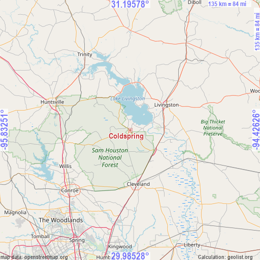
Coldspring GPS coordinates[2]
30° 35' 32.712" North, 95° 7' 45.768" West
| Map corner | latitude | longitude |
|---|---|---|
| Upper-left | 31.19578°, | -95.83251° |
| Center: | 30.59242°, | -95.12938° |
| Lower-right: | 29.98528°, | -94.42626° |
| Map W x H: | 134.6×134.6 km | = 83.6×83.6mi |
| max Lat: | 71.29058° ⇑91.5% North |
| Coldspring: | 30.59242° |
| min Lat: | ⇓8.5% South 19.06759° |
| min Long | Coldspring | max Long |
| -171.73463° | -95.12938° | -66.98998° |
| W 28.5%⇐ | ⇒71.5% E |
Elevation
Elevation of Coldspring is 114 m = 374 ft, and this is 180.8 m = 593 ft below average elevation for this country.
| Max E: |
3189 m = 10463 ft | 67.7% |
| Avg. | 294.8 m = 967 ft | |
| Coldspring | 114 m = 374 ft | |
Min E: |
-60 m = -197 ft | 32.3% |
See also: United States elevation on elevation.city.
Geographical zone
Coldspring is located in North temperate zone (between Tropic of Cancer and the Arctic Circle). Distance of this Northern Tropic circle is 795.6 km =494.4 mi to South.| Distance of | km | miles | from Coldspring |
|---|---|---|---|
| North Pole | 6605.5 | 4104.5 | to North |
| Arctic Circle | 3999.6 | 2485.2 | to North |
| Tropic Cancer | 795.6 | 494.4 | to South |
| Equator | 3401.6 | 2113.7 | to South |


Nearby cities:
15 places around Coldspring: (largest is in red/bold)
• Cleveland
28.2 km =17.5 mi,  171°
171°
• Cut and Shoot
36.2 km =22.5 mi,  217°
217°
• Huntsville
42.9 km =26.7 mi,  289°
289°
• Indian Springs
37.8 km =23.5 mi,  72°
72°
• Livingston
23 km =14.3 mi,  54°
54°
• New Waverly
34.4 km =21.4 mi,  259°
259°
• Onalaska
23.8 km =14.8 mi,  3°
3°
• Panorama Village
42.1 km =26.2 mi,  236°
236°
• Plum Grove
42.1 km =26.2 mi,  175°
175°
• Pointblank
18.8 km =11.7 mi,  334°
334°
• Riverside
39.1 km =24.3 mi,  317°
317°
• Shepherd
16.5 km =10.3 mi,  129°
129°
• Splendora
40.1 km =24.9 mi, 184°
• West Livingston
16.9 km =10.5 mi, 46°
• Willis
38.4 km =23.9 mi, 240°
Sources, notices
• [Note1] Compared only with cities in United States existing in our database
• [Src1] Map data: © OpenStreetMap contributors (CC-BY-SA)
• [Src2] Other city data from geonames.org with taken over terms of usage.
• [Src3] Geographical zone / Annual Mean Temperature by Robert A. Rohde @ Wikipedia
