Riverside geodata
Riverside (Texas) is a populated place; located in United States in America/Chicago (GMT-5) time zone. With population of 510 people, there are 20757 cities with bigger population in this country. Compared to other cities in United States, 91% of cities are located further ↑North; 72.1% of cities are located further →East and 77.1% of cities have higher elevation than Riverside. Note1


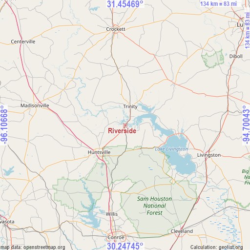
Riverside GPS coordinates[2]
30° 51' 10.692" North, 95° 24' 12.78" West
| Map corner | latitude | longitude |
|---|---|---|
| Upper-left | 31.45469°, | -96.10668° |
| Center: | 30.85297°, | -95.40355° |
| Lower-right: | 30.24745°, | -94.70043° |
| Map W x H: | 134.2×134.2 km | = 83.4×83.4mi |
| max Lat: | 71.29058° ⇑91% North |
| Riverside: | 30.85297° |
| min Lat: | ⇓9% South 19.06759° |
| min Long | Riverside | max Long |
| -171.73463° | -95.40355° | -66.98998° |
| W 27.9%⇐ | ⇒72.1% E |
Elevation
Elevation of Riverside is 60 m = 197 ft, and this is 234.8 m = 770 ft below average elevation for this country.
| Max E: |
3189 m = 10463 ft | 77.1% |
| Avg. | 294.8 m = 967 ft | |
| Riverside | 60 m = 197 ft | |
Min E: |
-60 m = -197 ft | 22.9% |
See also: United States elevation on elevation.city.
Geographical zone
Riverside is located in North temperate zone (between Tropic of Cancer and the Arctic Circle). Distance of this Northern Tropic circle is 824.6 km =512.4 mi to South.| Distance of | km | miles | from Riverside |
|---|---|---|---|
| North Pole | 6576.5 | 4086.4 | to North |
| Arctic Circle | 3970.6 | 2467.2 | to North |
| Tropic Cancer | 824.6 | 512.4 | to South |
| Equator | 3430.5 | 2131.6 | to South |


Nearby cities:
15 places around Riverside: (largest is in red/bold)
• Coldspring
39.1 km =24.3 mi,  137°
137°
• Cooper
46.6 km =29 mi,  338°
338°
• Crockett
52 km =32.3 mi,  354°
354°
• Groveton
34.7 km =21.6 mi,  49°
49°
• Huntsville
20.1 km =12.5 mi,  224°
224°
• Livingston
47.6 km =29.6 mi,  109°
109°
• Lovelady
30.7 km =19.1 mi, 352°
• Madisonville
49.7 km =30.9 mi,  282°
282°
• New Waverly
35.9 km =22.3 mi,  192°
192°
• Onalaska
27.9 km =17.3 mi,  100°
100°
• Panorama Village
53.2 km =33.1 mi, 189°
• Pointblank
21.8 km =13.5 mi,  123°
123°
• Trinity
10.6 km =6.6 mi,  14°
14°
• West Livingston
42.1 km =26.2 mi, 114°
• Willis
48.2 km =30 mi, 188°
Sources, notices
• [Note1] Compared only with cities in United States existing in our database
• [Src1] Map data: © OpenStreetMap contributors (CC-BY-SA)
• [Src2] Other city data from geonames.org with taken over terms of usage.
• [Src3] Geographical zone / Annual Mean Temperature by Robert A. Rohde @ Wikipedia
