Indian Springs geodata
Indian Springs (Texas) is a populated place; located in United States in America/Chicago (GMT-5) time zone. With population of 785 people, there are 17944 cities with bigger population in this country. Compared to other cities in United States, 91.3% of cities are located further ↑North; 70.5% of cities are located further →East and 66.6% of cities have higher elevation than Indian Springs. Note1


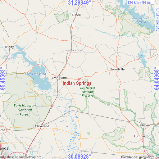
Indian Springs GPS coordinates[2]
30° 41' 44.808" North, 94° 45' 10.08" West
| Map corner | latitude | longitude |
|---|---|---|
| Upper-left | 31.29849°, | -95.45593° |
| Center: | 30.69578°, | -94.7528° |
| Lower-right: | 30.08928°, | -94.04968° |
| Map W x H: | 134.5×134.5 km | = 83.6×83.6mi |
| max Lat: | 71.29058° ⇑91.3% North |
| Indian Springs: | 30.69578° |
| min Lat: | ⇓8.7% South 19.06759° |
| min Long | Indian Springs | max Long |
| -171.73463° | -94.7528° | -66.98998° |
| W 29.5%⇐ | ⇒70.5% E |
Elevation
Elevation of Indian Springs is 120 m = 394 ft, and this is 174.8 m = 573 ft below average elevation for this country.
| Max E: |
3189 m = 10463 ft | 66.6% |
| Avg. | 294.8 m = 967 ft | |
| Indian Springs | 120 m = 394 ft | |
Min E: |
-60 m = -197 ft | 33.4% |
See also: United States elevation on elevation.city.
Geographical zone
Indian Springs is located in North temperate zone (between Tropic of Cancer and the Arctic Circle). Distance of this Northern Tropic circle is 807.1 km =501.5 mi to South.| Distance of | km | miles | from Indian Springs |
|---|---|---|---|
| North Pole | 6594 | 4097.3 | to North |
| Arctic Circle | 3988.1 | 2478.1 | to North |
| Tropic Cancer | 807.1 | 501.5 | to South |
| Equator | 3413.1 | 2120.8 | to South |


Nearby cities:
15 places around Indian Springs: (largest is in red/bold)
• Cleveland
50.7 km =31.5 mi,  218°
218°
• Coldspring
37.8 km =23.5 mi,  252°
252°
• Colmesneil
39.4 km =24.5 mi,  53°
53°
• Corrigan
34.2 km =21.3 mi,  348°
348°
• Diboll
54.7 km =34 mi,  357°
357°
• Groveton
53.5 km =33.2 mi,  318°
318°
• Livingston
17.3 km =10.7 mi,  275°
275°
• Onalaska
36.8 km =22.9 mi,  289°
289°
• Pleasant Hill
35.1 km =21.8 mi, 352°
• Pointblank
44.3 km =27.5 mi, 277°
• Shepherd
32.1 km =19.9 mi,  226°
226°
• Warren
34.1 km =21.2 mi,  105°
105°
• West Livingston
23.8 km =14.8 mi,  270°
270°
• Wildwood
35.4 km =22 mi,  122°
122°
• Woodville
33.4 km =20.8 mi,  74°
74°
Sources, notices
• [Note1] Compared only with cities in United States existing in our database
• [Src1] Map data: © OpenStreetMap contributors (CC-BY-SA)
• [Src2] Other city data from geonames.org with taken over terms of usage.
• [Src3] Geographical zone / Annual Mean Temperature by Robert A. Rohde @ Wikipedia
