Huntsville geodata
Huntsville (Texas) is a seat of a second-order administrative division; located in United States in America/Chicago (GMT-5) time zone. With population of 40,938 people, there are 1181 cities with bigger population in this country. Compared to other cities in United States, 91.2% of cities are located further ↑North; 72.5% of cities are located further →East and 67.3% of cities have higher elevation than Huntsville. Note1


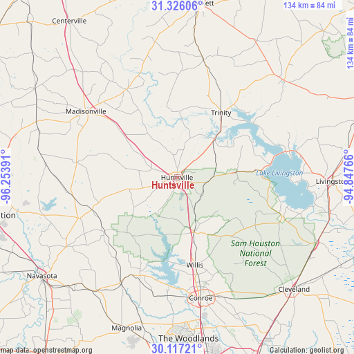
Huntsville GPS coordinates[2]
30° 43' 24.708" North, 95° 33' 2.808" West
| Map corner | latitude | longitude |
|---|---|---|
| Upper-left | 31.32606°, | -96.25391° |
| Center: | 30.72353°, | -95.55078° |
| Lower-right: | 30.11721°, | -94.84766° |
| Map W x H: | 134.4×134.4 km | = 83.5×83.5mi |
| max Lat: | 71.29058° ⇑91.2% North |
| Huntsville: | 30.72353° |
| min Lat: | ⇓8.8% South 19.06759° |
| min Long | Huntsville | max Long |
| -171.73463° | -95.55078° | -66.98998° |
| W 27.5%⇐ | ⇒72.5% E |
Elevation
Elevation of Huntsville is 116 m = 381 ft, and this is 178.8 m = 587 ft below average elevation for this country.
| Max E: |
3189 m = 10463 ft | 67.3% |
| Avg. | 294.8 m = 967 ft | |
| Huntsville | 116 m = 381 ft | |
Min E: |
-60 m = -197 ft | 32.7% |
See also: Huntsville elevation on elevation.city.
Geographical zone
Huntsville is located in North temperate zone (between Tropic of Cancer and the Arctic Circle). Distance of this Northern Tropic circle is 810.2 km =503.4 mi to South.| Distance of | km | miles | from Huntsville |
|---|---|---|---|
| North Pole | 6590.9 | 4095.4 | to North |
| Arctic Circle | 3985 | 2476.2 | to North |
| Tropic Cancer | 810.2 | 503.4 | to South |
| Equator | 3416.1 | 2122.7 | to South |


Nearby cities:
15 places around Huntsville: (largest is in red/bold)
• Anderson
49.3 km =30.6 mi,  237°
237°
• Coldspring
42.9 km =26.7 mi,  109°
109°
• Conroe
46.7 km =29 mi,  168°
168°
• Cut and Shoot
47.2 km =29.3 mi,  156°
156°
• Lovelady
46 km =28.6 mi,  12°
12°
• Madisonville
42.7 km =26.5 mi,  306°
306°
• Montgomery
39.8 km =24.7 mi,  200°
200°
• New Waverly
21.6 km =13.4 mi, 162°
• Onalaska
42.5 km =26.4 mi,  77°
77°
• Panorama Village
38.5 km =23.9 mi, 171°
• Pointblank
32.4 km =20.1 mi,  85°
85°
• Riverside
20.1 km =12.5 mi,  44°
44°
• Trinity
29.8 km =18.5 mi,  34°
34°
• West Livingston
52.5 km =32.6 mi, 93°
• Willis
33.9 km =21.1 mi, 168°
Sources, notices
• [Note1] Compared only with cities in United States existing in our database
• [Src1] Map data: © OpenStreetMap contributors (CC-BY-SA)
• [Src2] Other city data from geonames.org with taken over terms of usage.
• [Src3] Geographical zone / Annual Mean Temperature by Robert A. Rohde @ Wikipedia
