New Waverly geodata
New Waverly (Texas) is a populated place; located in United States in America/Chicago (GMT-5) time zone. With population of 1,040 people, there are 16023 cities with bigger population in this country. Compared to other cities in United States, 91.7% of cities are located further ↑North; 72.3% of cities are located further →East and 68.3% of cities have higher elevation than New Waverly. Note1


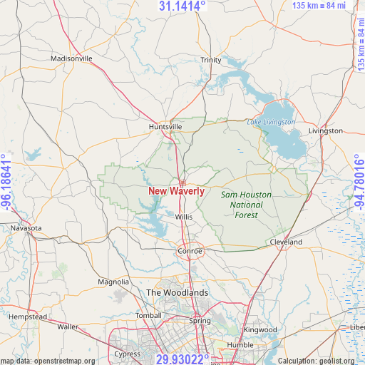
New Waverly GPS coordinates[2]
30° 32' 15.72" North, 95° 28' 59.808" West
| Map corner | latitude | longitude |
|---|---|---|
| Upper-left | 31.1414°, | -96.18641° |
| Center: | 30.5377°, | -95.48328° |
| Lower-right: | 29.93022°, | -94.78016° |
| Map W x H: | 134.7×134.7 km | = 83.7×83.7mi |
| max Lat: | 71.29058° ⇑91.7% North |
| New Waverly: | 30.5377° |
| min Lat: | ⇓8.3% South 19.06759° |
| min Long | New Waverly | max Long |
| -171.73463° | -95.48328° | -66.98998° |
| W 27.7%⇐ | ⇒72.3% E |
Elevation
Elevation of New Waverly is 111 m = 364 ft, and this is 183.8 m = 603 ft below average elevation for this country.
| Max E: |
3189 m = 10463 ft | 68.3% |
| Avg. | 294.8 m = 967 ft | |
| New Waverly | 111 m = 364 ft | |
Min E: |
-60 m = -197 ft | 31.7% |
See also: United States elevation on elevation.city.
Geographical zone
New Waverly is located in North temperate zone (between Tropic of Cancer and the Arctic Circle). Distance of this Northern Tropic circle is 789.6 km =490.6 mi to South.| Distance of | km | miles | from New Waverly |
|---|---|---|---|
| North Pole | 6611.6 | 4108.3 | to North |
| Arctic Circle | 4005.7 | 2489 | to North |
| Tropic Cancer | 789.6 | 490.6 | to South |
| Equator | 3395.5 | 2109.9 | to South |


Nearby cities:
15 places around New Waverly: (largest is in red/bold)
• Cleveland
43.9 km =27.3 mi,  119°
119°
• Coldspring
34.4 km =21.4 mi,  79°
79°
• Conroe
25.2 km =15.7 mi,  174°
174°
• Cut and Shoot
25.7 km =16 mi,  152°
152°
• Huntsville
21.6 km =13.4 mi,  342°
342°
• Magnolia
44.6 km =27.7 mi,  215°
215°
• Montgomery
26.3 km =16.3 mi,  230°
230°
• Oak Ridge North
42.1 km =26.2 mi, 174°
• Panorama Village
17.4 km =10.8 mi,  183°
183°
• Pinehurst
45 km =28 mi,  205°
205°
• Pointblank
34.7 km =21.6 mi,  48°
48°
• Riverside
35.9 km =22.3 mi,  12°
12°
• Shenandoah
39.8 km =24.7 mi, 176°
• The Woodlands
42.2 km =26.2 mi, 180°
• Willis
12.5 km =7.8 mi, 178°
Sources, notices
• [Note1] Compared only with cities in United States existing in our database
• [Src1] Map data: © OpenStreetMap contributors (CC-BY-SA)
• [Src2] Other city data from geonames.org with taken over terms of usage.
• [Src3] Geographical zone / Annual Mean Temperature by Robert A. Rohde @ Wikipedia
