Cypress geodata
Cypress (Texas) is a populated place; located in United States in America/Chicago (GMT-5) time zone. With population of 46,025 people, there are 1042 cities with bigger population in this country. Compared to other cities in United States, 93.5% of cities are located further ↑North; 72.8% of cities are located further →East and 79% of cities have higher elevation than Cypress. Note1


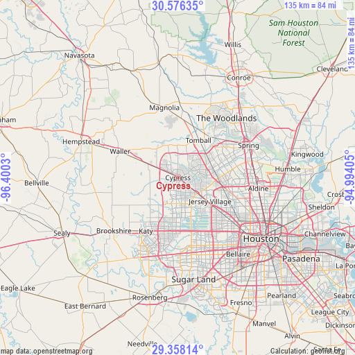
Cypress GPS coordinates[2]
29° 58' 8.796" North, 95° 41' 49.812" West
| Map corner | latitude | longitude |
|---|---|---|
| Upper-left | 30.57635°, | -96.4003° |
| Center: | 29.96911°, | -95.69717° |
| Lower-right: | 29.35814°, | -94.99405° |
| Map W x H: | 135.5×135.5 km | = 84.2×84.2mi |
| max Lat: | 71.29058° ⇑93.5% North |
| Cypress: | 29.96911° |
| min Lat: | ⇓6.5% South 19.06759° |
| min Long | Cypress | max Long |
| -171.73463° | -95.69717° | -66.98998° |
| W 27.2%⇐ | ⇒72.8% E |
Elevation
Elevation of Cypress is 51 m = 167 ft, and this is 243.8 m = 800 ft below average elevation for this country.
| Max E: |
3189 m = 10463 ft | 79% |
| Avg. | 294.8 m = 967 ft | |
| Cypress | 51 m = 167 ft | |
Min E: |
-60 m = -197 ft | 21% |
See also: Cypress elevation on elevation.city.
Geographical zone
Cypress is located in North temperate zone (between Tropic of Cancer and the Arctic Circle). Distance of this Northern Tropic circle is 726.3 km =451.3 mi to South.| Distance of | km | miles | from Cypress |
|---|---|---|---|
| North Pole | 6674.8 | 4147.5 | to North |
| Arctic Circle | 4068.9 | 2528.3 | to North |
| Tropic Cancer | 726.3 | 451.3 | to South |
| Equator | 3332.3 | 2070.6 | to South |


Nearby cities:
15 places around Cypress: (largest is in red/bold)
• Bunker Hill Village
27.6 km =17.1 mi,  144°
144°
• Cinco Ranch
26.3 km =16.3 mi,  192°
192°
• Hedwig Village
27.5 km =17.1 mi, 140°
• Hilshire Village
28.2 km =17.5 mi,  134°
134°
• Hudson
20.2 km =12.6 mi,  111°
111°
• Jersey Village
15.8 km =9.8 mi,  124°
124°
• Katy
23.8 km =14.8 mi,  211°
211°
• Magnolia
27.2 km =16.9 mi,  349°
349°
• Oak Cliff Place
8.2 km =5.1 mi, 124°
• Pinehurst
22.5 km =14 mi,  3°
3°
• Spring Valley
27.3 km =17 mi, 136°
• Stagecoach
19.7 km =12.2 mi,  355°
355°
• The Woodlands
29 km =18 mi,  43°
43°
• Tomball
16.2 km =10.1 mi,  28°
28°
• Waller
24.2 km =15 mi,  293°
293°
Sources, notices
• [Note1] Compared only with cities in United States existing in our database
• [Src1] Map data: © OpenStreetMap contributors (CC-BY-SA)
• [Src2] Other city data from geonames.org with taken over terms of usage.
• [Src3] Geographical zone / Annual Mean Temperature by Robert A. Rohde @ Wikipedia
