Oak Cliff Place geodata
Oak Cliff Place (Texas) is a populated place; located in United States in America/Chicago (GMT-5) time zone. With population of 1,800 people, there are 12537 cities with bigger population in this country. Compared to other cities in United States, 93.6% of cities are located further ↑North; 72.7% of cities are located further →East and 81.3% of cities have higher elevation than Oak Cliff Place. Note1


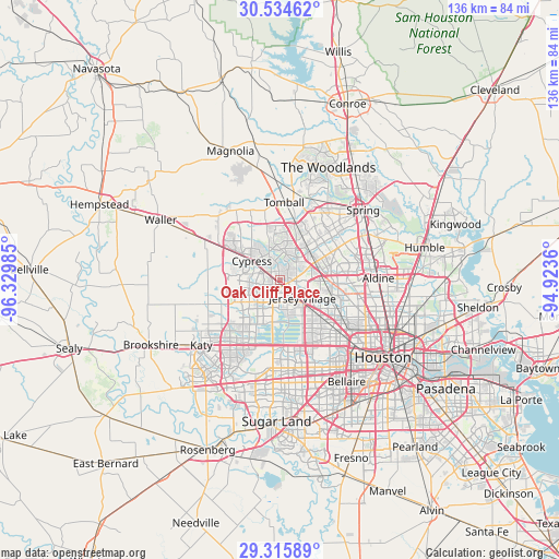
Oak Cliff Place GPS coordinates[2]
29° 55' 37.632" North, 95° 37' 36.192" West
| Map corner | latitude | longitude |
|---|---|---|
| Upper-left | 30.53462°, | -96.32985° |
| Center: | 29.92712°, | -95.62672° |
| Lower-right: | 29.31589°, | -94.9236° |
| Map W x H: | 135.5×135.5 km | = 84.2×84.2mi |
| max Lat: | 71.29058° ⇑93.6% North |
| Oak Cliff Place: | 29.92712° |
| min Lat: | ⇓6.4% South 19.06759° |
| min Long | Oak Cliff Place | max Long |
| -171.73463° | -95.62672° | -66.98998° |
| W 27.3%⇐ | ⇒72.7% E |
Elevation
Elevation of Oak Cliff Place is 41 m = 135 ft, and this is 253.8 m = 833 ft below average elevation for this country.
| Max E: |
3189 m = 10463 ft | 81.3% |
| Avg. | 294.8 m = 967 ft | |
| Oak Cliff Place | 41 m = 135 ft | |
Min E: |
-60 m = -197 ft | 18.7% |
See also: United States elevation on elevation.city.
Geographical zone
Oak Cliff Place is located in North temperate zone (between Tropic of Cancer and the Arctic Circle). Distance of this Northern Tropic circle is 721.7 km =448.4 mi to South.| Distance of | km | miles | from Oak Cliff Place |
|---|---|---|---|
| North Pole | 6679.5 | 4150.4 | to North |
| Arctic Circle | 4073.6 | 2531.2 | to North |
| Tropic Cancer | 721.7 | 448.4 | to South |
| Equator | 3327.6 | 2067.7 | to South |


Nearby cities:
15 places around Oak Cliff Place: (largest is in red/bold)
• Aldine
23.8 km =14.8 mi,  88°
88°
• Alief
24.2 km =15 mi,  173°
173°
• Bunker Hill Village
20.1 km =12.5 mi,  152°
152°
• Cinco Ranch
24.5 km =15.2 mi,  211°
211°
• Cypress
8.2 km =5.1 mi,  304°
304°
• Hedwig Village
19.7 km =12.2 mi, 147°
• Hilshire Village
20.1 km =12.5 mi,  138°
138°
• Hudson
12.3 km =7.6 mi,  102°
102°
• Hunters Creek Village
21.5 km =13.4 mi, 143°
• Jersey Village
7.5 km =4.7 mi,  125°
125°
• Katy
24.7 km =15.3 mi,  230°
230°
• Piney Point Village
21.4 km =13.3 mi, 150°
• Spring Valley
19.4 km =12.1 mi, 142°
• Stagecoach
25.7 km =16 mi,  341°
341°
• Tomball
18.9 km =11.7 mi,  3°
3°
Sources, notices
• [Note1] Compared only with cities in United States existing in our database
• [Src1] Map data: © OpenStreetMap contributors (CC-BY-SA)
• [Src2] Other city data from geonames.org with taken over terms of usage.
• [Src3] Geographical zone / Annual Mean Temperature by Robert A. Rohde @ Wikipedia
