Tomball geodata
Tomball (Texas) is a populated place; located in United States in America/Chicago (GMT-5) time zone. With population of 11,540 people, there are 4013 cities with bigger population in this country. Compared to other cities in United States, 93.1% of cities are located further ↑North; 72.6% of cities are located further →East and 77.3% of cities have higher elevation than Tomball. Note1


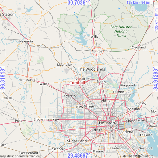
Tomball GPS coordinates[2]
30° 5' 49.776" North, 95° 36' 57.78" West
| Map corner | latitude | longitude |
|---|---|---|
| Upper-left | 30.70361°, | -96.31918° |
| Center: | 30.09716°, | -95.61605° |
| Lower-right: | 29.48697°, | -94.91293° |
| Map W x H: | 135.3×135.3 km | = 84.1×84.1mi |
| max Lat: | 71.29058° ⇑93.1% North |
| Tomball: | 30.09716° |
| min Lat: | ⇓6.9% South 19.06759° |
| min Long | Tomball | max Long |
| -171.73463° | -95.61605° | -66.98998° |
| W 27.4%⇐ | ⇒72.6% E |
Elevation
Elevation of Tomball is 59 m = 194 ft, and this is 235.8 m = 774 ft below average elevation for this country.
| Max E: |
3189 m = 10463 ft | 77.3% |
| Avg. | 294.8 m = 967 ft | |
| Tomball | 59 m = 194 ft | |
Min E: |
-60 m = -197 ft | 22.7% |
See also: United States elevation on elevation.city.
Geographical zone
Tomball is located in North temperate zone (between Tropic of Cancer and the Arctic Circle). Distance of this Northern Tropic circle is 740.6 km =460.2 mi to South.| Distance of | km | miles | from Tomball |
|---|---|---|---|
| North Pole | 6660.6 | 4138.7 | to North |
| Arctic Circle | 4054.7 | 2519.5 | to North |
| Tropic Cancer | 740.6 | 460.2 | to South |
| Equator | 3346.5 | 2079.4 | to South |


Nearby cities:
15 places around Tomball: (largest is in red/bold)
• Aldine
29.2 km =18.1 mi,  128°
128°
• Conroe
28.4 km =17.6 mi,  32°
32°
• Cypress
16.2 km =10.1 mi,  208°
208°
• Hudson
24.3 km =15.1 mi,  153°
153°
• Jersey Village
23.8 km =14.8 mi,  167°
167°
• Magnolia
18 km =11.2 mi,  313°
313°
• Oak Cliff Place
18.9 km =11.7 mi,  183°
183°
• Oak Ridge North
17.9 km =11.1 mi,  66°
66°
• Pinehurst
10.4 km =6.5 mi,  322°
322°
• Porter Heights
28.9 km =18 mi,  77°
77°
• Shenandoah
18 km =11.2 mi,  59°
59°
• Spring
19.2 km =11.9 mi,  95°
95°
• Stagecoach
10.8 km =6.7 mi,  299°
299°
• The Woodlands
13.9 km =8.6 mi, 60°
• Waller
30.2 km =18.8 mi,  261°
261°
Sources, notices
• [Note1] Compared only with cities in United States existing in our database
• [Src1] Map data: © OpenStreetMap contributors (CC-BY-SA)
• [Src2] Other city data from geonames.org with taken over terms of usage.
• [Src3] Geographical zone / Annual Mean Temperature by Robert A. Rohde @ Wikipedia
