Stagecoach geodata
Stagecoach (Texas) is a populated place; located in United States in America/Chicago (GMT-5) time zone. With population of 583 people, there are 19876 cities with bigger population in this country. Compared to other cities in United States, 93% of cities are located further ↑North; 72.9% of cities are located further →East and 75.8% of cities have higher elevation than Stagecoach. Note1


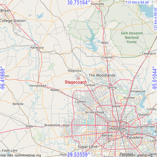
Stagecoach GPS coordinates[2]
30° 8' 43.764" North, 95° 42' 48.816" West
| Map corner | latitude | longitude |
|---|---|---|
| Upper-left | 30.75164°, | -96.41669° |
| Center: | 30.14549°, | -95.71356° |
| Lower-right: | 29.53559°, | -95.01044° |
| Map W x H: | 135.2×135.2 km | = 84×84mi |
| max Lat: | 71.29058° ⇑93% North |
| Stagecoach: | 30.14549° |
| min Lat: | ⇓7% South 19.06759° |
| min Long | Stagecoach | max Long |
| -171.73463° | -95.71356° | -66.98998° |
| W 27.1%⇐ | ⇒72.9% E |
Elevation
Elevation of Stagecoach is 67 m = 220 ft, and this is 227.8 m = 747 ft below average elevation for this country.
| Max E: |
3189 m = 10463 ft | 75.8% |
| Avg. | 294.8 m = 967 ft | |
| Stagecoach | 67 m = 220 ft | |
Min E: |
-60 m = -197 ft | 24.2% |
See also: United States elevation on elevation.city.
Geographical zone
Stagecoach is located in North temperate zone (between Tropic of Cancer and the Arctic Circle). Distance of this Northern Tropic circle is 745.9 km =463.5 mi to South.| Distance of | km | miles | from Stagecoach |
|---|---|---|---|
| North Pole | 6655.2 | 4135.3 | to North |
| Arctic Circle | 4049.3 | 2516.1 | to North |
| Tropic Cancer | 745.9 | 463.5 | to South |
| Equator | 3351.9 | 2082.8 | to South |


Nearby cities:
15 places around Stagecoach: (largest is in red/bold)
• Conroe
30.9 km =19.2 mi,  53°
53°
• Cypress
19.7 km =12.2 mi,  175°
175°
• Jersey Village
32.1 km =19.9 mi,  153°
153°
• Magnolia
8 km =5 mi,  333°
333°
• Montgomery
27 km =16.8 mi,  3°
3°
• Oak Cliff Place
25.7 km =16 mi,  161°
161°
• Oak Ridge North
25.9 km =16.1 mi,  86°
86°
• Pine Island
32.6 km =20.3 mi,  252°
252°
• Pinehurst
4.1 km =2.5 mi, 46°
• Prairie View
27 km =16.8 mi,  257°
257°
• Shenandoah
25.1 km =15.6 mi,  81°
81°
• Spring
29.4 km =18.3 mi,  104°
104°
• The Woodlands
21.6 km =13.4 mi, 86°
• Tomball
10.8 km =6.7 mi,  119°
119°
• Waller
22.8 km =14.2 mi,  244°
244°
Sources, notices
• [Note1] Compared only with cities in United States existing in our database
• [Src1] Map data: © OpenStreetMap contributors (CC-BY-SA)
• [Src2] Other city data from geonames.org with taken over terms of usage.
• [Src3] Geographical zone / Annual Mean Temperature by Robert A. Rohde @ Wikipedia
