Irving geodata
Irving (Texas) is a populated place; located in United States in America/Chicago (GMT-5) time zone. With population of 236,607 people, there are 102 cities with bigger population in this country. Compared to other cities in United States, 85.9% of cities are located further ↑North; 75.6% of cities are located further →East and 60.7% of cities have higher elevation than Irving. Note1


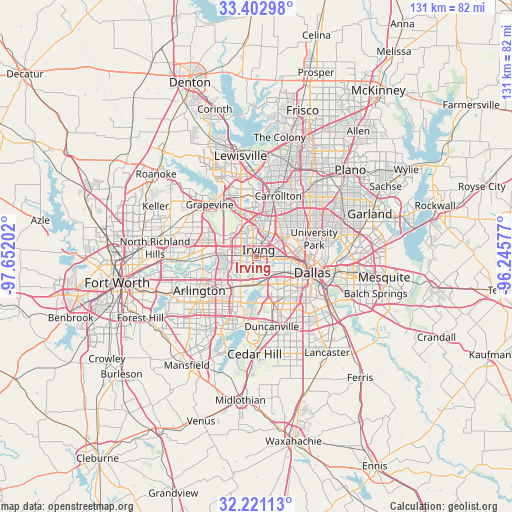
Irving GPS coordinates[2]
32° 48' 50.472" North, 96° 56' 56.004" West
| Map corner | latitude | longitude |
|---|---|---|
| Upper-left | 33.40298°, | -97.65202° |
| Center: | 32.81402°, | -96.94889° |
| Lower-right: | 32.22113°, | -96.24577° |
| Map W x H: | 131.4×131.4 km | = 81.6×81.6mi |
| max Lat: | 71.29058° ⇑85.9% North |
| Irving: | 32.81402° |
| min Lat: | ⇓14.1% South 19.06759° |
| min Long | Irving | max Long |
| -171.73463° | -96.94889° | -66.98998° |
| W 24.4%⇐ | ⇒75.6% E |
Elevation
Elevation of Irving is 151 m = 495 ft, and this is 143.8 m = 472 ft below average elevation for this country.
| Max E: |
3189 m = 10463 ft | 60.7% |
| Avg. | 294.8 m = 967 ft | |
| Irving | 151 m = 495 ft | |
Min E: |
-60 m = -197 ft | 39.3% |
See also: Irving elevation on elevation.city.
Geographical zone
Irving is located in North temperate zone (between Tropic of Cancer and the Arctic Circle). Distance of this Northern Tropic circle is 1042.7 km =647.9 mi to South.| Distance of | km | miles | from Irving |
|---|---|---|---|
| North Pole | 6358.5 | 3951 | to North |
| Arctic Circle | 3752.6 | 2331.8 | to North |
| Tropic Cancer | 1042.7 | 647.9 | to South |
| Equator | 3648.6 | 2267.1 | to South |


Nearby cities:
15 places around Irving: (largest is in red/bold)
• Addison
19.9 km =12.4 mi,  34°
34°
• Arlington
17.2 km =10.7 mi,  239°
239°
• Bedford
18.4 km =11.4 mi,  280°
280°
• Carrollton
16.5 km =10.3 mi,  19°
19°
• Cockrell Hill
10.4 km =6.5 mi,  146°
146°
• Colleyville
20.6 km =12.8 mi,  291°
291°
• Coppell
16.8 km =10.4 mi,  338°
338°
• Dallas
13.7 km =8.5 mi,  104°
104°
• Duncanville
18.4 km =11.4 mi,  168°
168°
• Euless
12.7 km =7.9 mi, 281°
• Farmers Branch
13.4 km =8.3 mi, 21°
• Grand Prairie
8.8 km =5.5 mi,  211°
211°
• Grapevine
18 km =11.2 mi,  317°
317°
• Highland Park
14.8 km =9.2 mi,  81°
81°
• University Park
14.5 km =9 mi,  73°
73°
Sources, notices
• [Note1] Compared only with cities in United States existing in our database
• [Src1] Map data: © OpenStreetMap contributors (CC-BY-SA)
• [Src2] Other city data from geonames.org with taken over terms of usage.
• [Src3] Geographical zone / Annual Mean Temperature by Robert A. Rohde @ Wikipedia
