Arlington geodata
Arlington (Texas) is a populated place; located in United States in America/Chicago (GMT-5) time zone. With population of 388,125 people, there are 55 cities with bigger population in this country. Compared to other cities in United States, 86.2% of cities are located further ↑North; 76% of cities are located further →East and 52.2% of cities have higher elevation than Arlington. Note1


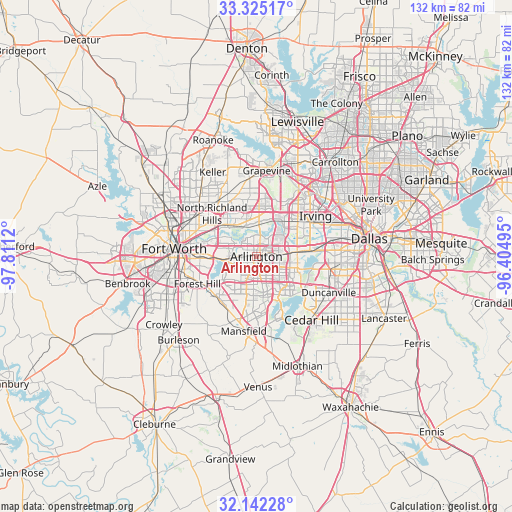
Arlington GPS coordinates[2]
32° 44' 8.484" North, 97° 6' 29.052" West
| Map corner | latitude | longitude |
|---|---|---|
| Upper-left | 33.32517°, | -97.8112° |
| Center: | 32.73569°, | -97.10807° |
| Lower-right: | 32.14228°, | -96.40495° |
| Map W x H: | 131.5×131.5 km | = 81.7×81.7mi |
| max Lat: | 71.29058° ⇑86.2% North |
| Arlington: | 32.73569° |
| min Lat: | ⇓13.8% South 19.06759° |
| min Long | Arlington | max Long |
| -171.73463° | -97.10807° | -66.98998° |
| W 24%⇐ | ⇒76% E |
Elevation
Elevation of Arlington is 190 m = 623 ft, and this is 104.8 m = 344 ft below average elevation for this country.
| Max E: |
3189 m = 10463 ft | 52.2% |
| Avg. | 294.8 m = 967 ft | |
| Arlington | 190 m = 623 ft | |
Min E: |
-60 m = -197 ft | 47.8% |
See also: Arlington elevation on elevation.city.
Geographical zone
Arlington is located in North temperate zone (between Tropic of Cancer and the Arctic Circle). Distance of this Northern Tropic circle is 1033.9 km =642.4 mi to South.| Distance of | km | miles | from Arlington |
|---|---|---|---|
| North Pole | 6367.2 | 3956.4 | to North |
| Arctic Circle | 3761.3 | 2337.2 | to North |
| Tropic Cancer | 1033.9 | 642.4 | to South |
| Equator | 3639.9 | 2261.7 | to South |


Nearby cities:
15 places around Arlington: (largest is in red/bold)
• Bedford
12.5 km =7.8 mi,  344°
344°
• Colleyville
16.7 km =10.4 mi, 344°
• Dalworthington Gardens
5.7 km =3.5 mi,  230°
230°
• Euless
11.5 km =7.1 mi,  12°
12°
• Forest Hill
16.7 km =10.4 mi,  244°
244°
• Grand Prairie
10.4 km =6.5 mi,  83°
83°
• Haltom City
16.7 km =10.4 mi,  295°
295°
• Hurst
11.4 km =7.1 mi,  329°
329°
• Irving
17.2 km =10.7 mi,  59°
59°
• Kennedale
14.8 km =9.2 mi, 228°
• Mansfield
19.4 km =12.1 mi,  189°
189°
• North Richland Hills
15.7 km =9.8 mi,  314°
314°
• Pantego
5.1 km =3.2 mi, 242°
• Richland Hills
14.3 km =8.9 mi, 308°
• Watauga
19.3 km =12 mi, 314°
Sources, notices
• [Note1] Compared only with cities in United States existing in our database
• [Src1] Map data: © OpenStreetMap contributors (CC-BY-SA)
• [Src2] Other city data from geonames.org with taken over terms of usage.
• [Src3] Geographical zone / Annual Mean Temperature by Robert A. Rohde @ Wikipedia
