Freer geodata
Freer (Texas) is a populated place; located in United States in America/Chicago (GMT-5) time zone. With population of 2,732 people, there are 10119 cities with bigger population in this country. Compared to other cities in United States, 96.8% of cities are located further ↑North; 79.5% of cities are located further →East and 59% of cities have higher elevation than Freer. Note1


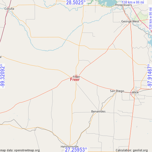
Freer GPS coordinates[2]
27° 52' 58.08" North, 98° 37' 4.044" West
| Map corner | latitude | longitude |
|---|---|---|
| Upper-left | 28.5025°, | -99.32092° |
| Center: | 27.8828°, | -98.61779° |
| Lower-right: | 27.25953°, | -97.91467° |
| Map W x H: | 138.2×138.2 km | = 85.9×85.9mi |
| max Lat: | 71.29058° ⇑96.8% North |
| Freer: | 27.8828° |
| min Lat: | ⇓3.2% South 19.06759° |
| min Long | Freer | max Long |
| -171.73463° | -98.61779° | -66.98998° |
| W 20.5%⇐ | ⇒79.5% E |
Elevation
Elevation of Freer is 160 m = 525 ft, and this is 134.8 m = 442 ft below average elevation for this country.
| Max E: |
3189 m = 10463 ft | 59% |
| Avg. | 294.8 m = 967 ft | |
| Freer | 160 m = 525 ft | |
Min E: |
-60 m = -197 ft | 41% |
See also: United States elevation on elevation.city.
Geographical zone
Freer is located in North temperate zone (between Tropic of Cancer and the Arctic Circle). Distance of this Northern Tropic circle is 494.4 km =307.2 mi to South.| Distance of | km | miles | from Freer |
|---|---|---|---|
| North Pole | 6906.8 | 4291.7 | to North |
| Arctic Circle | 4300.9 | 2672.5 | to North |
| Tropic Cancer | 494.4 | 307.2 | to South |
| Equator | 3100.3 | 1926.4 | to South |


Nearby cities:
15 places around Freer: (largest is in red/bold)
• Agua Dulce
70.6 km =43.9 mi,  99°
99°
• Alice
55.8 km =34.7 mi,  105°
105°
• Benavides
37.7 km =23.4 mi,  146°
146°
• Cactus
76.3 km =47.4 mi,  272°
272°
• Coyote Acres
51.2 km =31.8 mi, 111°
• Encinal
74.5 km =46.3 mi,  283°
283°
• George West
70.1 km =43.6 mi,  44°
44°
• Hebbronville
64.3 km =40 mi,  185°
185°
• Lake City
75.1 km =46.7 mi,  73°
73°
• Orange Grove
67.4 km =41.9 mi,  82°
82°
• Premont
75.8 km =47.1 mi,  140°
140°
• Rancho Alegre
53.8 km =33.4 mi, 106°
• San Diego
39.5 km =24.5 mi, 109°
• Three Rivers
77.1 km =47.9 mi,  33°
33°
• Tilden
64.7 km =40.2 mi,  5°
5°
Sources, notices
• [Note1] Compared only with cities in United States existing in our database
• [Src1] Map data: © OpenStreetMap contributors (CC-BY-SA)
• [Src2] Other city data from geonames.org with taken over terms of usage.
• [Src3] Geographical zone / Annual Mean Temperature by Robert A. Rohde @ Wikipedia
