Pflugerville geodata
Pflugerville (Texas) is a populated place; located in United States in America/Chicago (GMT-5) time zone. With population of 57,122 people, there are 797 cities with bigger population in this country. Compared to other cities in United States, 92% of cities are located further ↑North; 77.5% of cities are located further →East and 56.4% of cities have lower elevation than Pflugerville. Note1


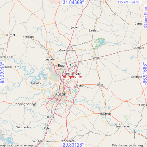
Pflugerville GPS coordinates[2]
30° 26' 21.732" North, 97° 37' 12" West
| Map corner | latitude | longitude |
|---|---|---|
| Upper-left | 31.04369°, | -98.32313° |
| Center: | 30.43937°, | -97.62° |
| Lower-right: | 29.83128°, | -96.91688° |
| Map W x H: | 134.8×134.8 km | = 83.8×83.8mi |
| max Lat: | 71.29058° ⇑92% North |
| Pflugerville: | 30.43937° |
| min Lat: | ⇓8% South 19.06759° |
| min Long | Pflugerville | max Long |
| -171.73463° | -97.62° | -66.98998° |
| W 22.5%⇐ | ⇒77.5% E |
Elevation
Elevation of Pflugerville is 224 m = 735 ft, and this is 70.8 m = 232 ft below average elevation for this country.
| Max E: |
3189 m = 10463 ft | 43.6% |
| Avg. | 294.8 m = 967 ft | |
| Pflugerville | 224 m = 735 ft | |
Min E: |
-60 m = -197 ft | 56.4% |
See also: Pflugerville elevation on elevation.city.
Geographical zone
Pflugerville is located in North temperate zone (between Tropic of Cancer and the Arctic Circle). Distance of this Northern Tropic circle is 778.6 km =483.8 mi to South.| Distance of | km | miles | from Pflugerville |
|---|---|---|---|
| North Pole | 6622.5 | 4115 | to North |
| Arctic Circle | 4016.6 | 2495.8 | to North |
| Tropic Cancer | 778.6 | 483.8 | to South |
| Equator | 3384.5 | 2103 | to South |


Nearby cities:
15 places around Pflugerville: (largest is in red/bold)
• Anderson Mill
17.9 km =11.1 mi,  275°
275°
• Austin
22.5 km =14 mi,  211°
211°
• Brushy Creek
14.1 km =8.8 mi,  305°
305°
• Cedar Park
20.5 km =12.7 mi,  290°
290°
• Georgetown
22.2 km =13.8 mi,  345°
345°
• Hornsby Bend
21.6 km =13.4 mi,  170°
170°
• Hutto
13.5 km =8.4 mi,  31°
31°
• Jollyville
14.9 km =9.3 mi,  271°
271°
• Manor
12.5 km =7.8 mi,  151°
151°
• Rollingwood
24.4 km =15.2 mi,  222°
222°
• Round Rock
9.5 km =5.9 mi,  323°
323°
• Taylor
24.9 km =15.5 mi,  54°
54°
• Wells Branch
5.7 km =3.5 mi, 277°
• West Lake Hills
23.5 km =14.6 mi,  227°
227°
• Windemere
3.6 km =2.2 mi, 308°
Sources, notices
• [Note1] Compared only with cities in United States existing in our database
• [Src1] Map data: © OpenStreetMap contributors (CC-BY-SA)
• [Src2] Other city data from geonames.org with taken over terms of usage.
• [Src3] Geographical zone / Annual Mean Temperature by Robert A. Rohde @ Wikipedia
