Groveton geodata
Groveton (Texas) is a seat of a second-order administrative division; located in United States in America/Chicago (GMT-5) time zone. With population of 1,024 people, there are 16121 cities with bigger population in this country. Compared to other cities in United States, 90.6% of cities are located further ↑North; 71.5% of cities are located further →East and 69.7% of cities have higher elevation than Groveton. Note1


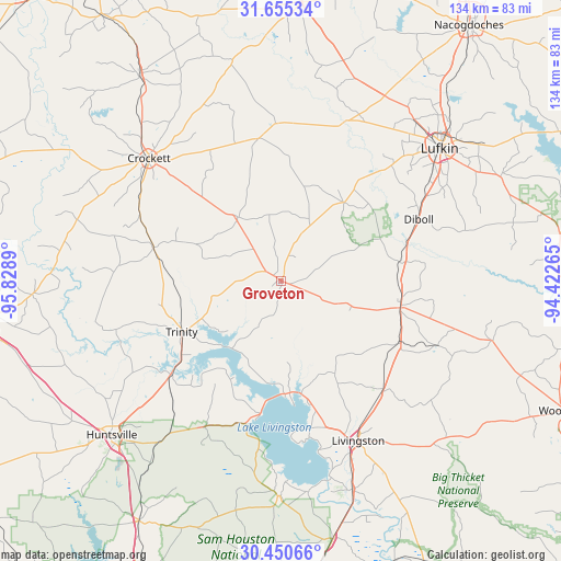
Groveton GPS coordinates[2]
31° 3' 17.676" North, 95° 7' 32.772" West
| Map corner | latitude | longitude |
|---|---|---|
| Upper-left | 31.65534°, | -95.8289° |
| Center: | 31.05491°, | -95.12577° |
| Lower-right: | 30.45066°, | -94.42265° |
| Map W x H: | 133.9×133.9 km | = 83.2×83.2mi |
| max Lat: | 71.29058° ⇑90.6% North |
| Groveton: | 31.05491° |
| min Lat: | ⇓9.4% South 19.06759° |
| min Long | Groveton | max Long |
| -171.73463° | -95.12577° | -66.98998° |
| W 28.5%⇐ | ⇒71.5% E |
Elevation
Elevation of Groveton is 102 m = 335 ft, and this is 192.8 m = 633 ft below average elevation for this country.
| Max E: |
3189 m = 10463 ft | 69.7% |
| Avg. | 294.8 m = 967 ft | |
| Groveton | 102 m = 335 ft | |
Min E: |
-60 m = -197 ft | 30.3% |
See also: United States elevation on elevation.city.
Geographical zone
Groveton is located in North temperate zone (between Tropic of Cancer and the Arctic Circle). Distance of this Northern Tropic circle is 847.1 km =526.4 mi to South.| Distance of | km | miles | from Groveton |
|---|---|---|---|
| North Pole | 6554.1 | 4072.5 | to North |
| Arctic Circle | 3948.2 | 2453.3 | to North |
| Tropic Cancer | 847.1 | 526.4 | to South |
| Equator | 3453 | 2145.6 | to South |


Nearby cities:
15 places around Groveton: (largest is in red/bold)
• Burke
39.3 km =24.4 mi,  59°
59°
• Cooper
48.2 km =30 mi,  295°
295°
• Corrigan
29.2 km =18.1 mi,  102°
102°
• Crockett
43 km =26.7 mi,  312°
312°
• Diboll
36 km =22.4 mi,  65°
65°
• Hickory Creek
40.5 km =25.2 mi,  332°
332°
• Hudson
44.5 km =27.7 mi,  47°
47°
• Livingston
42.4 km =26.3 mi,  154°
154°
• Lovelady
31.5 km =19.6 mi,  284°
284°
• Onalaska
27.7 km =17.2 mi,  178°
178°
• Pleasant Hill
31.7 km =19.7 mi, 99°
• Pointblank
35.4 km =22 mi,  193°
193°
• Riverside
34.7 km =21.6 mi,  229°
229°
• Trinity
26.7 km =16.6 mi,  242°
242°
• West Livingston
41.4 km =25.7 mi,  163°
163°
Sources, notices
• [Note1] Compared only with cities in United States existing in our database
• [Src1] Map data: © OpenStreetMap contributors (CC-BY-SA)
• [Src2] Other city data from geonames.org with taken over terms of usage.
• [Src3] Geographical zone / Annual Mean Temperature by Robert A. Rohde @ Wikipedia
