Pleasant Hill geodata
Pleasant Hill (Texas) is a populated place; located in United States in America/Chicago (GMT-5) time zone. With population of 522 people, there are 20606 cities with bigger population in this country. Compared to other cities in United States, 90.7% of cities are located further ↑North; 70.6% of cities are located further →East and 74.7% of cities have higher elevation than Pleasant Hill. Note1


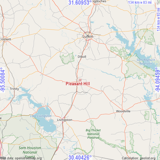
Pleasant Hill GPS coordinates[2]
31° 0' 31.68" North, 94° 47' 51.756" West
| Map corner | latitude | longitude |
|---|---|---|
| Upper-left | 31.60953°, | -95.50084° |
| Center: | 31.0088°, | -94.79771° |
| Lower-right: | 30.40426°, | -94.09459° |
| Map W x H: | 134×134 km | = 83.3×83.3mi |
| max Lat: | 71.29058° ⇑90.7% North |
| Pleasant Hill: | 31.0088° |
| min Lat: | ⇓9.3% South 19.06759° |
| min Long | Pleasant Hill | max Long |
| -171.73463° | -94.79771° | -66.98998° |
| W 29.4%⇐ | ⇒70.6% E |
Elevation
Elevation of Pleasant Hill is 73 m = 240 ft, and this is 221.8 m = 728 ft below average elevation for this country.
| Max E: |
3189 m = 10463 ft | 74.7% |
| Avg. | 294.8 m = 967 ft | |
| Pleasant Hill | 73 m = 240 ft | |
Min E: |
-60 m = -197 ft | 25.3% |
See also: United States elevation on elevation.city.
Geographical zone
Pleasant Hill is located in North temperate zone (between Tropic of Cancer and the Arctic Circle). Distance of this Northern Tropic circle is 841.9 km =523.1 mi to South.| Distance of | km | miles | from Pleasant Hill |
|---|---|---|---|
| North Pole | 6559.2 | 4075.7 | to North |
| Arctic Circle | 3953.3 | 2456.5 | to North |
| Tropic Cancer | 841.9 | 523.1 | to South |
| Equator | 3447.9 | 2142.4 | to South |


Nearby cities:
15 places around Pleasant Hill: (largest is in red/bold)
• Burke
25 km =15.5 mi,  6°
6°
• Colmesneil
37.5 km =23.3 mi,  107°
107°
• Corrigan
3.1 km =1.9 mi,  244°
244°
• Diboll
19.9 km =12.4 mi,  4°
4°
• Groveton
31.7 km =19.7 mi,  279°
279°
• Hudson
34.9 km =21.7 mi, 3°
• Huntington
36.6 km =22.7 mi,  35°
35°
• Indian Springs
35.1 km =21.8 mi,  172°
172°
• Livingston
35.5 km =22.1 mi,  201°
201°
• Lufkin
37.2 km =23.1 mi, 10°
• Onalaska
37.9 km =23.5 mi,  233°
233°
• Redland
44.6 km =27.7 mi, 9°
• West Livingston
39.7 km =24.7 mi,  209°
209°
• Woodville
44.8 km =27.8 mi,  125°
125°
• Zavalla
39.1 km =24.3 mi,  64°
64°
Sources, notices
• [Note1] Compared only with cities in United States existing in our database
• [Src1] Map data: © OpenStreetMap contributors (CC-BY-SA)
• [Src2] Other city data from geonames.org with taken over terms of usage.
• [Src3] Geographical zone / Annual Mean Temperature by Robert A. Rohde @ Wikipedia
