Lovelady geodata
Lovelady (Texas) is a populated place; located in United States in America/Chicago (GMT-5) time zone. With population of 620 people, there are 19469 cities with bigger population in this country. Compared to other cities in United States, 90.5% of cities are located further ↑North; 72.2% of cities are located further →East and 71.7% of cities have higher elevation than Lovelady. Note1


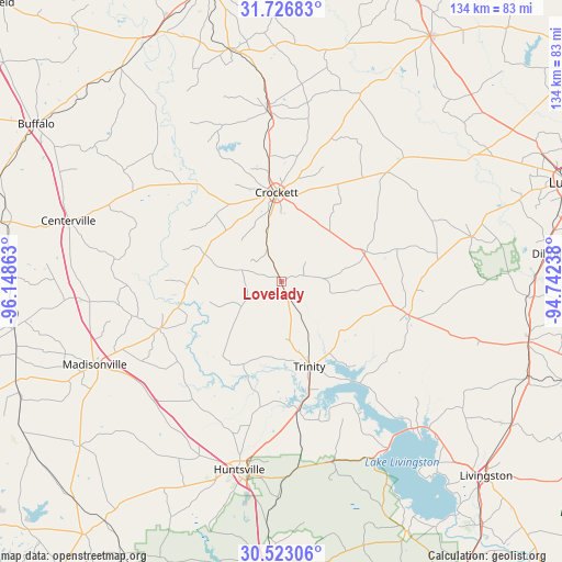
Lovelady GPS coordinates[2]
31° 7' 36.66" North, 95° 26' 43.8" West
| Map corner | latitude | longitude |
|---|---|---|
| Upper-left | 31.72683°, | -96.14863° |
| Center: | 31.12685°, | -95.4455° |
| Lower-right: | 30.52306°, | -94.74238° |
| Map W x H: | 133.8×133.8 km | = 83.1×83.1mi |
| max Lat: | 71.29058° ⇑90.5% North |
| Lovelady: | 31.12685° |
| min Lat: | ⇓9.5% South 19.06759° |
| min Long | Lovelady | max Long |
| -171.73463° | -95.4455° | -66.98998° |
| W 27.8%⇐ | ⇒72.2% E |
Elevation
Elevation of Lovelady is 91 m = 299 ft, and this is 203.8 m = 669 ft below average elevation for this country.
| Max E: |
3189 m = 10463 ft | 71.7% |
| Avg. | 294.8 m = 967 ft | |
| Lovelady | 91 m = 299 ft | |
Min E: |
-60 m = -197 ft | 28.3% |
See also: United States elevation on elevation.city.
Geographical zone
Lovelady is located in North temperate zone (between Tropic of Cancer and the Arctic Circle). Distance of this Northern Tropic circle is 855.1 km =531.3 mi to South.| Distance of | km | miles | from Lovelady |
|---|---|---|---|
| North Pole | 6546.1 | 4067.6 | to North |
| Arctic Circle | 3940.2 | 2448.3 | to North |
| Tropic Cancer | 855.1 | 531.3 | to South |
| Equator | 3461 | 2150.6 | to South |


Nearby cities:
15 places around Lovelady: (largest is in red/bold)
• Centerville
52.7 km =32.7 mi,  286°
286°
• Cooper
18.3 km =11.4 mi,  314°
314°
• Corrigan
60.6 km =37.7 mi,  103°
103°
• Crockett
21.3 km =13.2 mi,  357°
357°
• Elkhart
56.8 km =35.3 mi,  347°
347°
• Grapeland
40.7 km =25.3 mi, 355°
• Groveton
31.5 km =19.6 mi, 104°
• Hickory Creek
30.4 km =18.9 mi,  22°
22°
• Huntsville
46 km =28.6 mi,  192°
192°
• Madisonville
48.6 km =30.2 mi,  246°
246°
• Onalaska
47.5 km =29.5 mi,  138°
138°
• Pointblank
47.8 km =29.7 mi,  152°
152°
• Riverside
30.7 km =19.1 mi,  172°
172°
• San Pedro
39.4 km =24.5 mi,  9°
9°
• Trinity
21.3 km =13.2 mi,  161°
161°
Sources, notices
• [Note1] Compared only with cities in United States existing in our database
• [Src1] Map data: © OpenStreetMap contributors (CC-BY-SA)
• [Src2] Other city data from geonames.org with taken over terms of usage.
• [Src3] Geographical zone / Annual Mean Temperature by Robert A. Rohde @ Wikipedia
