Harper geodata
Harper (Texas) is a populated place; located in United States in America/Chicago (GMT-5) time zone. With population of 1,192 people, there are 15165 cities with bigger population in this country. Compared to other cities in United States, 92.5% of cities are located further ↑North; 80.1% of cities are located further →East and 90% of cities have lower elevation than Harper. Note1


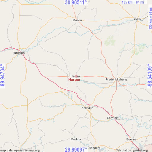
Harper GPS coordinates[2]
30° 17' 59.712" North, 99° 14' 39.156" West
| Map corner | latitude | longitude |
|---|---|---|
| Upper-left | 30.90511°, | -99.94734° |
| Center: | 30.29992°, | -99.24421° |
| Lower-right: | 29.69097°, | -98.54109° |
| Map W x H: | 135×135 km | = 83.9×83.9mi |
| max Lat: | 71.29058° ⇑92.5% North |
| Harper: | 30.29992° |
| min Lat: | ⇓7.5% South 19.06759° |
| min Long | Harper | max Long |
| -171.73463° | -99.24421° | -66.98998° |
| W 19.9%⇐ | ⇒80.1% E |
Elevation
Elevation of Harper is 627 m = 2057 ft, and this is 332.2 m = 1090 ft above average elevation for this country.
| Max E: |
3189 m = 10463 ft | 10% |
| Harper | 627 m 2057 ft | |
| Avg. | 294.8 m = 967 ft | |
Min E: |
-60 m = -197 ft | 90% |
See also: United States elevation on elevation.city.
Geographical zone
Harper is located in North temperate zone (between Tropic of Cancer and the Arctic Circle). Distance of this Northern Tropic circle is 763.1 km =474.2 mi to South.| Distance of | km | miles | from Harper |
|---|---|---|---|
| North Pole | 6638 | 4124.7 | to North |
| Arctic Circle | 4032.1 | 2505.4 | to North |
| Tropic Cancer | 763.1 | 474.2 | to South |
| Equator | 3369 | 2093.4 | to South |


Nearby cities:
15 places around Harper: (largest is in red/bold)
• Bandera
65.8 km =40.9 mi,  165°
165°
• Blanco
82.2 km =51.1 mi,  105°
105°
• Boerne
74.7 km =46.4 mi,  138°
138°
• Comfort
49.3 km =30.6 mi, 138°
• Fredericksburg
35.8 km =22.2 mi,  94°
94°
• Ingram
24.7 km =15.3 mi,  179°
179°
• Johnson City
79.9 km =49.6 mi, 91°
• Junction
54.8 km =34.1 mi,  292°
292°
• Kerrville
29.8 km =18.5 mi,  160°
160°
• Lakehills
82.6 km =51.3 mi, 159°
• Leakey
80.7 km =50.1 mi,  218°
218°
• Llano
74.7 km =46.4 mi,  46°
46°
• Mason
49.9 km =31 mi,  1°
1°
• Medina
56 km =34.8 mi, 180°
• Stonewall
56.1 km =34.9 mi,  97°
97°
Sources, notices
• [Note1] Compared only with cities in United States existing in our database
• [Src1] Map data: © OpenStreetMap contributors (CC-BY-SA)
• [Src2] Other city data from geonames.org with taken over terms of usage.
• [Src3] Geographical zone / Annual Mean Temperature by Robert A. Rohde @ Wikipedia
