Blanco geodata
Blanco (Texas) is a populated place; located in United States in America/Chicago (GMT-5) time zone. With population of 1,889 people, there are 12253 cities with bigger population in this country. Compared to other cities in United States, 93.1% of cities are located further ↑North; 79.2% of cities are located further →East and 84.2% of cities have lower elevation than Blanco. Note1


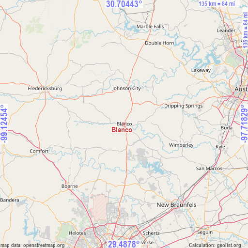
Blanco GPS coordinates[2]
30° 5' 52.764" North, 98° 25' 17.076" West
| Map corner | latitude | longitude |
|---|---|---|
| Upper-left | 30.70443°, | -99.12454° |
| Center: | 30.09799°, | -98.42141° |
| Lower-right: | 29.4878°, | -97.71829° |
| Map W x H: | 135.3×135.3 km | = 84.1×84.1mi |
| max Lat: | 71.29058° ⇑93.1% North |
| Blanco: | 30.09799° |
| min Lat: | ⇓6.9% South 19.06759° |
| min Long | Blanco | max Long |
| -171.73463° | -98.42141° | -66.98998° |
| W 20.8%⇐ | ⇒79.2% E |
Elevation
Elevation of Blanco is 408 m = 1339 ft, and this is 113.2 m = 371 ft above average elevation for this country.
| Max E: |
3189 m = 10463 ft | 15.8% |
| Blanco | 408 m 1339 ft | |
| Avg. | 294.8 m = 967 ft | |
Min E: |
-60 m = -197 ft | 84.2% |
See also: United States elevation on elevation.city.
Geographical zone
Blanco is located in North temperate zone (between Tropic of Cancer and the Arctic Circle). Distance of this Northern Tropic circle is 740.7 km =460.2 mi to South.| Distance of | km | miles | from Blanco |
|---|---|---|---|
| North Pole | 6660.5 | 4138.6 | to North |
| Arctic Circle | 4054.6 | 2519.4 | to North |
| Tropic Cancer | 740.7 | 460.2 | to South |
| Equator | 3346.6 | 2079.5 | to South |


Nearby cities:
15 places around Blanco: (largest is in red/bold)
• Boerne
45.1 km =28 mi,  221°
221°
• Briarcliff
49.9 km =31 mi,  46°
46°
• Bulverde
39.5 km =24.5 mi,  184°
184°
• Canyon Lake
29.1 km =18.1 mi,  148°
148°
• Comfort
48.8 km =30.3 mi,  252°
252°
• Dripping Springs
33.8 km =21 mi,  72°
72°
• Fair Oaks Ranch
44.6 km =27.7 mi,  208°
208°
• Fredericksburg
47.6 km =29.6 mi,  294°
294°
• Horseshoe Bay
49.8 km =30.9 mi,  5°
5°
• Johnson City
19.9 km =12.4 mi,  2°
2°
• Scenic Oaks
49.5 km =30.8 mi, 209°
• Stonewall
28 km =17.4 mi,  303°
303°
• Timberwood Park
44 km =27.3 mi,  187°
187°
• Wimberley
33 km =20.5 mi,  109°
109°
• Woodcreek
30.8 km =19.1 mi,  104°
104°
Sources, notices
• [Note1] Compared only with cities in United States existing in our database
• [Src1] Map data: © OpenStreetMap contributors (CC-BY-SA)
• [Src2] Other city data from geonames.org with taken over terms of usage.
• [Src3] Geographical zone / Annual Mean Temperature by Robert A. Rohde @ Wikipedia
