Stonewall geodata
Stonewall (Texas) is a populated place; located in United States in America/Chicago (GMT-5) time zone. With population of 505 people, there are 20828 cities with bigger population in this country. Compared to other cities in United States, 92.7% of cities are located further ↑North; 79.6% of cities are located further →East and 86.2% of cities have lower elevation than Stonewall. Note1


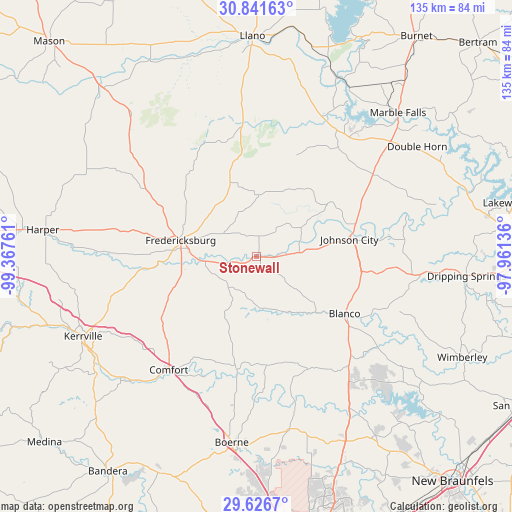
Stonewall GPS coordinates[2]
30° 14' 9.744" North, 98° 39' 52.128" West
| Map corner | latitude | longitude |
|---|---|---|
| Upper-left | 30.84163°, | -99.36761° |
| Center: | 30.23604°, | -98.66448° |
| Lower-right: | 29.6267°, | -97.96136° |
| Map W x H: | 135.1×135.1 km | = 83.9×83.9mi |
| max Lat: | 71.29058° ⇑92.7% North |
| Stonewall: | 30.23604° |
| min Lat: | ⇓7.3% South 19.06759° |
| min Long | Stonewall | max Long |
| -171.73463° | -98.66448° | -66.98998° |
| W 20.4%⇐ | ⇒79.6% E |
Elevation
Elevation of Stonewall is 447 m = 1467 ft, and this is 152.2 m = 499 ft above average elevation for this country.
| Max E: |
3189 m = 10463 ft | 13.8% |
| Stonewall | 447 m 1467 ft | |
| Avg. | 294.8 m = 967 ft | |
Min E: |
-60 m = -197 ft | 86.2% |
See also: United States elevation on elevation.city.
Geographical zone
Stonewall is located in North temperate zone (between Tropic of Cancer and the Arctic Circle). Distance of this Northern Tropic circle is 756 km =469.8 mi to South.| Distance of | km | miles | from Stonewall |
|---|---|---|---|
| North Pole | 6645.1 | 4129.1 | to North |
| Arctic Circle | 4039.2 | 2509.8 | to North |
| Tropic Cancer | 756 | 469.8 | to South |
| Equator | 3361.9 | 2089 | to South |


Nearby cities:
15 places around Stonewall: (largest is in red/bold)
• Blanco
28 km =17.4 mi,  123°
123°
• Boerne
49.5 km =30.8 mi,  187°
187°
• Canyon Lake
55.7 km =34.6 mi,  136°
136°
• Comfort
37.8 km =23.5 mi,  217°
217°
• Cottonwood Shores
48.3 km =30 mi,  42°
42°
• Fair Oaks Ranch
54.5 km =33.9 mi,  177°
177°
• Fredericksburg
20.4 km =12.7 mi,  282°
282°
• Granite Shoals
47.6 km =29.6 mi,  34°
34°
• Horseshoe Bay
44.2 km =27.5 mi, 39°
• Johnson City
24.7 km =15.3 mi,  79°
79°
• Kerrville
50.3 km =31.3 mi,  245°
245°
• Kingsland
51.6 km =32.1 mi,  24°
24°
• Marble Falls
53.3 km =33.1 mi, 44°
• Meadowlakes
50.5 km =31.4 mi, 44°
• Sunrise Beach Village
47.2 km =29.3 mi, 31°
Sources, notices
• [Note1] Compared only with cities in United States existing in our database
• [Src1] Map data: © OpenStreetMap contributors (CC-BY-SA)
• [Src2] Other city data from geonames.org with taken over terms of usage.
• [Src3] Geographical zone / Annual Mean Temperature by Robert A. Rohde @ Wikipedia
