Kerrville geodata
Kerrville (Texas) is a seat of a second-order administrative division; located in United States in America/Chicago (GMT-5) time zone. With population of 23,136 people, there are 2176 cities with bigger population in this country. Compared to other cities in United States, 93.3% of cities are located further ↑North; 80% of cities are located further →East and 87.9% of cities have lower elevation than Kerrville. Note1


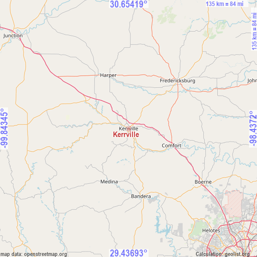
Kerrville GPS coordinates[2]
30° 2' 50.748" North, 99° 8' 25.152" West
| Map corner | latitude | longitude |
|---|---|---|
| Upper-left | 30.65419°, | -99.84345° |
| Center: | 30.04743°, | -99.14032° |
| Lower-right: | 29.43693°, | -98.4372° |
| Map W x H: | 135.3×135.3 km | = 84.1×84.1mi |
| max Lat: | 71.29058° ⇑93.3% North |
| Kerrville: | 30.04743° |
| min Lat: | ⇓6.7% South 19.06759° |
| min Long | Kerrville | max Long |
| -171.73463° | -99.14032° | -66.98998° |
| W 20%⇐ | ⇒80% E |
Elevation
Elevation of Kerrville is 501 m = 1644 ft, and this is 206.2 m = 677 ft above average elevation for this country.
| Max E: |
3189 m = 10463 ft | 12.1% |
| Kerrville | 501 m 1644 ft | |
| Avg. | 294.8 m = 967 ft | |
Min E: |
-60 m = -197 ft | 87.9% |
See also: United States elevation on elevation.city.
Geographical zone
Kerrville is located in North temperate zone (between Tropic of Cancer and the Arctic Circle). Distance of this Northern Tropic circle is 735 km =456.7 mi to South.| Distance of | km | miles | from Kerrville |
|---|---|---|---|
| North Pole | 6666.1 | 4142.1 | to North |
| Arctic Circle | 4060.2 | 2522.9 | to North |
| Tropic Cancer | 735 | 456.7 | to South |
| Equator | 3341 | 2076 | to South |


Nearby cities:
15 places around Kerrville: (largest is in red/bold)
• Bandera
36.2 km =22.5 mi,  169°
169°
• Blanco
69.4 km =43.1 mi,  85°
85°
• Boerne
48.4 km =30.1 mi,  125°
125°
• Comfort
24.3 km =15.1 mi,  111°
111°
• Cross Mountain
64.4 km =40 mi, 133°
• Fair Oaks Ranch
58.5 km =36.4 mi,  124°
124°
• Fredericksburg
36.2 km =22.5 mi,  45°
45°
• Grey Forest
65.3 km =40.6 mi,  137°
137°
• Harper
29.8 km =18.5 mi,  340°
340°
• Helotes
67.9 km =42.2 mi, 140°
• Ingram
10.2 km =6.3 mi,  289°
289°
• Lakehills
52.8 km =32.8 mi,  158°
158°
• Medina
29.7 km =18.5 mi,  200°
200°
• Scenic Oaks
58.4 km =36.3 mi, 129°
• Stonewall
50.3 km =31.3 mi,  65°
65°
Sources, notices
• [Note1] Compared only with cities in United States existing in our database
• [Src1] Map data: © OpenStreetMap contributors (CC-BY-SA)
• [Src2] Other city data from geonames.org with taken over terms of usage.
• [Src3] Geographical zone / Annual Mean Temperature by Robert A. Rohde @ Wikipedia
