Marshall geodata
Marshall (Texas) is a seat of a second-order administrative division; located in United States in America/Chicago (GMT-5) time zone. With population of 23,820 people, there are 2124 cities with bigger population in this country. Compared to other cities in United States, 86.9% of cities are located further ↑North; 69.6% of cities are located further →East and 64.8% of cities have higher elevation than Marshall. Note1


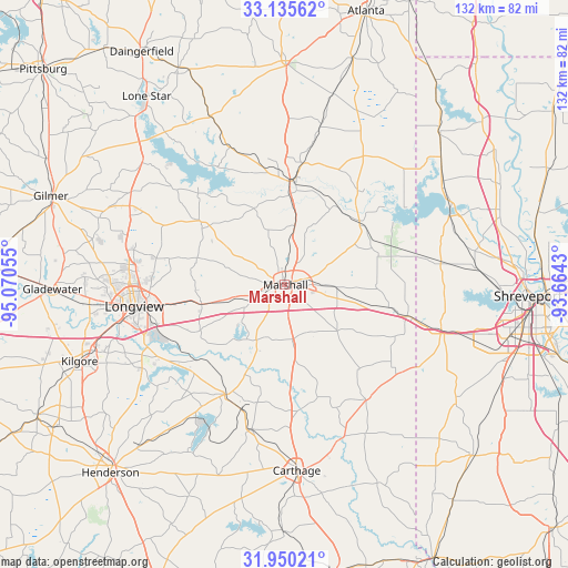
Marshall GPS coordinates[2]
32° 32' 41.532" North, 94° 22' 2.712" West
| Map corner | latitude | longitude |
|---|---|---|
| Upper-left | 33.13562°, | -95.07055° |
| Center: | 32.54487°, | -94.36742° |
| Lower-right: | 31.95021°, | -93.6643° |
| Map W x H: | 131.8×131.8 km | = 81.9×81.9mi |
| max Lat: | 71.29058° ⇑86.9% North |
| Marshall: | 32.54487° |
| min Lat: | ⇓13.1% South 19.06759° |
| min Long | Marshall | max Long |
| -171.73463° | -94.36742° | -66.98998° |
| W 30.4%⇐ | ⇒69.6% E |
Elevation
Elevation of Marshall is 129 m = 423 ft, and this is 165.8 m = 544 ft below average elevation for this country.
| Max E: |
3189 m = 10463 ft | 64.8% |
| Avg. | 294.8 m = 967 ft | |
| Marshall | 129 m = 423 ft | |
Min E: |
-60 m = -197 ft | 35.2% |
See also: United States elevation on elevation.city.
Geographical zone
Marshall is located in North temperate zone (between Tropic of Cancer and the Arctic Circle). Distance of this Northern Tropic circle is 1012.7 km =629.3 mi to South.| Distance of | km | miles | from Marshall |
|---|---|---|---|
| North Pole | 6388.4 | 3969.6 | to North |
| Arctic Circle | 3782.5 | 2350.3 | to North |
| Tropic Cancer | 1012.7 | 629.3 | to South |
| Equator | 3618.7 | 2248.6 | to South |


Nearby cities:
15 places around Marshall: (largest is in red/bold)
• Beckville
34.6 km =21.5 mi,  193°
193°
• Blanchard
44.7 km =27.8 mi,  84°
84°
• Carthage
43.2 km =26.8 mi,  176°
176°
• East Mountain
46.1 km =28.6 mi,  276°
276°
• Easton
26.8 km =16.7 mi,  229°
229°
• Greenwood
38.7 km =24 mi,  107°
107°
• Hallsville
19.9 km =12.4 mi,  256°
256°
• Jefferson
23.7 km =14.7 mi,  5°
5°
• Lakeport
35.1 km =21.8 mi,  244°
244°
• Longview
35.3 km =21.9 mi, 262°
• Mooringsport
41.2 km =25.6 mi,  67°
67°
• Oil City
43.2 km =26.8 mi,  59°
59°
• Ore City
43.6 km =27.1 mi,  310°
310°
• Tatum
29 km =18 mi,  208°
208°
• Waskom
29.8 km =18.5 mi,  104°
104°
Sources, notices
• [Note1] Compared only with cities in United States existing in our database
• [Src1] Map data: © OpenStreetMap contributors (CC-BY-SA)
• [Src2] Other city data from geonames.org with taken over terms of usage.
• [Src3] Geographical zone / Annual Mean Temperature by Robert A. Rohde @ Wikipedia
