Hallsville geodata
Hallsville (Texas) is a populated place; located in United States in America/Chicago (GMT-5) time zone. With population of 4,065 people, there are 8144 cities with bigger population in this country. Compared to other cities in United States, 87.1% of cities are located further ↑North; 70% of cities are located further →East and 67.7% of cities have higher elevation than Hallsville. Note1


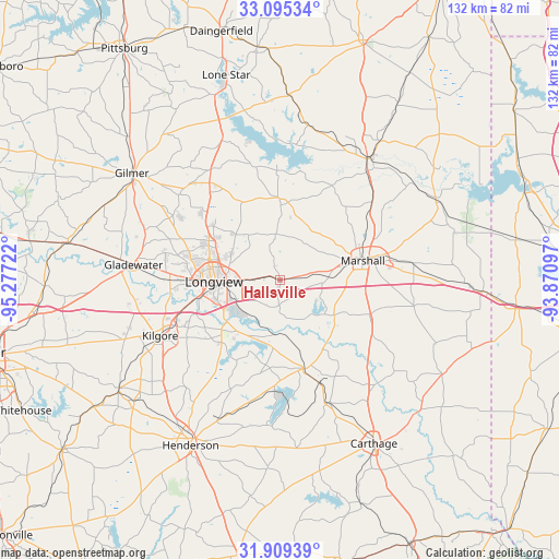
Hallsville GPS coordinates[2]
32° 30' 15.552" North, 94° 34' 26.724" West
| Map corner | latitude | longitude |
|---|---|---|
| Upper-left | 33.09534°, | -95.27722° |
| Center: | 32.50432°, | -94.57409° |
| Lower-right: | 31.90939°, | -93.87097° |
| Map W x H: | 131.9×131.9 km | = 82×82mi |
| max Lat: | 71.29058° ⇑87.1% North |
| Hallsville: | 32.50432° |
| min Lat: | ⇓12.9% South 19.06759° |
| min Long | Hallsville | max Long |
| -171.73463° | -94.57409° | -66.98998° |
| W 30%⇐ | ⇒70% E |
Elevation
Elevation of Hallsville is 114 m = 374 ft, and this is 180.8 m = 593 ft below average elevation for this country.
| Max E: |
3189 m = 10463 ft | 67.7% |
| Avg. | 294.8 m = 967 ft | |
| Hallsville | 114 m = 374 ft | |
Min E: |
-60 m = -197 ft | 32.3% |
See also: United States elevation on elevation.city.
Geographical zone
Hallsville is located in North temperate zone (between Tropic of Cancer and the Arctic Circle). Distance of this Northern Tropic circle is 1008.2 km =626.5 mi to South.| Distance of | km | miles | from Hallsville |
|---|---|---|---|
| North Pole | 6392.9 | 3972.4 | to North |
| Arctic Circle | 3787 | 2353.1 | to North |
| Tropic Cancer | 1008.2 | 626.5 | to South |
| Equator | 3614.1 | 2245.7 | to South |


Nearby cities:
15 places around Hallsville: (largest is in red/bold)
• Beckville
31.1 km =19.3 mi,  159°
159°
• Clarksville City
31 km =19.3 mi,  275°
275°
• East Mountain
28.2 km =17.5 mi,  290°
290°
• Easton
13 km =8.1 mi,  183°
183°
• Gilmer
42.6 km =26.5 mi,  305°
305°
• Gladewater
34.7 km =21.6 mi, 275°
• Jefferson
35.4 km =22 mi,  37°
37°
• Kilgore
31.2 km =19.4 mi,  245°
245°
• Lakeport
16.2 km =10.1 mi,  229°
229°
• Liberty City
35.7 km =22.2 mi,  259°
259°
• Longview
15.6 km =9.7 mi,  268°
268°
• Marshall
19.9 km =12.4 mi,  76°
76°
• Ore City
35.6 km =22.1 mi,  337°
337°
• Tatum
21.6 km =13.4 mi,  165°
165°
• White Oak
27.1 km =16.8 mi, 275°
Sources, notices
• [Note1] Compared only with cities in United States existing in our database
• [Src1] Map data: © OpenStreetMap contributors (CC-BY-SA)
• [Src2] Other city data from geonames.org with taken over terms of usage.
• [Src3] Geographical zone / Annual Mean Temperature by Robert A. Rohde @ Wikipedia
