Oak Ridge North geodata
Oak Ridge North (Texas) is a populated place; located in United States in America/Chicago (GMT-5) time zone. With population of 3,161 people, there are 9360 cities with bigger population in this country. Compared to other cities in United States, 92.9% of cities are located further ↑North; 72.2% of cities are located further →East and 79.5% of cities have higher elevation than Oak Ridge North. Note1


Oak Ridge North GPS coordinates[2]
30° 9' 36.792" North, 95° 26' 39.768" West
| Map corner | latitude | longitude |
|---|---|---|
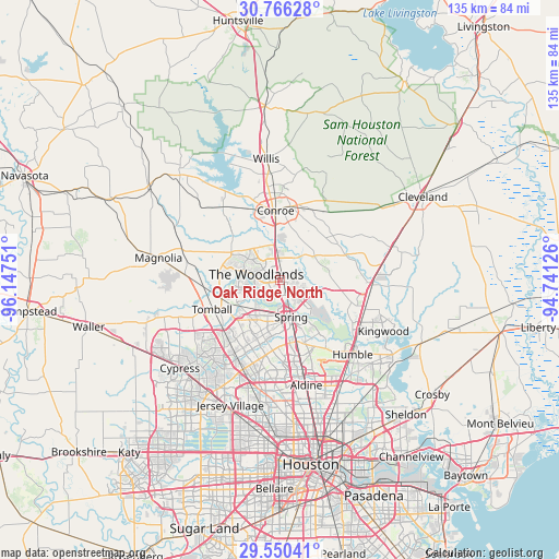
| Upper-left | 30.76628°, | -96.14751° |
| Center: | 30.16022°, | -95.44438° |
| Lower-right: | 29.55041°, | -94.74126° |
| Map W x H: | 135.2×135.2 km | = 84×84mi |
| max Lat: | 71.29058° ⇑92.9% North |
| Oak Ridge North: | 30.16022° |
| min Lat: | ⇓7.1% South 19.06759° |
| min Long | Oak Ridge North | max Long |
| -171.73463° | -95.44438° | -66.98998° |
| W 27.8%⇐ | ⇒72.2% E |
Elevation
Elevation of Oak Ridge North is 49 m = 161 ft, and this is 245.8 m = 806 ft below average elevation for this country.
| Max E: |
3189 m = 10463 ft | 79.5% |
| Avg. | 294.8 m = 967 ft | |
| Oak Ridge North | 49 m = 161 ft | |
Min E: |
-60 m = -197 ft | 20.5% |
See also: United States elevation on elevation.city.
Geographical zone
Oak Ridge North is located in North temperate zone (between Tropic of Cancer and the Arctic Circle). Distance of this Northern Tropic circle is 747.6 km =464.5 mi to South.| Distance of | km | miles | from Oak Ridge North |
|---|---|---|---|
| North Pole | 6653.6 | 4134.4 | to North |
| Arctic Circle | 4047.7 | 2515.1 | to North |
| Tropic Cancer | 747.6 | 464.5 | to South |
| Equator | 3353.5 | 2083.8 | to South |


Nearby cities:
15 places around Oak Ridge North: (largest is in red/bold)
• Aldine
26.1 km =16.2 mi,  166°
166°
• Conroe
16.9 km =10.5 mi,  356°
356°
• Cut and Shoot
21 km =13 mi,  23°
23°
• Humble
25.1 km =15.6 mi,  135°
135°
• Kingwood Area
22.6 km =14 mi,  128°
128°
• Panorama Village
25 km =15.5 mi,  349°
349°
• Patton Village
26.7 km =16.6 mi,  82°
82°
• Pinehurst
22.9 km =14.2 mi,  273°
273°
• Porter Heights
11.8 km =7.3 mi,  94°
94°
• Shenandoah
2.5 km =1.6 mi,  333°
333°
• Spring
9.3 km =5.8 mi,  163°
163°
• Stagecoach
25.9 km =16.1 mi, 266°
• The Woodlands
4.3 km =2.7 mi, 266°
• Tomball
17.9 km =11.1 mi,  246°
246°
• Woodbranch
24.7 km =15.3 mi, 84°
Sources, notices
• [Note1] Compared only with cities in United States existing in our database
• [Src1] Map data: © OpenStreetMap contributors (CC-BY-SA)
• [Src2] Other city data from geonames.org with taken over terms of usage.
• [Src3] Geographical zone / Annual Mean Temperature by Robert A. Rohde @ Wikipedia
