Conroe geodata
Conroe (Texas) is a seat of a second-order administrative division; located in United States in America/Chicago (GMT-5) time zone. With population of 68,602 people, there are 607 cities with bigger population in this country. Compared to other cities in United States, 92.5% of cities are located further ↑North; 72.2% of cities are located further →East and 75.5% of cities have higher elevation than Conroe. Note1


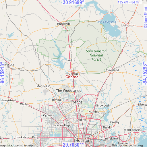
Conroe GPS coordinates[2]
30° 18' 42.768" North, 95° 27' 21.78" West
| Map corner | latitude | longitude |
|---|---|---|
| Upper-left | 30.91699°, | -96.15918° |
| Center: | 30.31188°, | -95.45605° |
| Lower-right: | 29.70301°, | -94.75293° |
| Map W x H: | 135×135 km | = 83.9×83.9mi |
| max Lat: | 71.29058° ⇑92.5% North |
| Conroe: | 30.31188° |
| min Lat: | ⇓7.5% South 19.06759° |
| min Long | Conroe | max Long |
| -171.73463° | -95.45605° | -66.98998° |
| W 27.8%⇐ | ⇒72.2% E |
Elevation
Elevation of Conroe is 69 m = 226 ft, and this is 225.8 m = 741 ft below average elevation for this country.
| Max E: |
3189 m = 10463 ft | 75.5% |
| Avg. | 294.8 m = 967 ft | |
| Conroe | 69 m = 226 ft | |
Min E: |
-60 m = -197 ft | 24.5% |
See also: Conroe elevation on elevation.city.
Geographical zone
Conroe is located in North temperate zone (between Tropic of Cancer and the Arctic Circle). Distance of this Northern Tropic circle is 764.4 km =475 mi to South.| Distance of | km | miles | from Conroe |
|---|---|---|---|
| North Pole | 6636.7 | 4123.9 | to North |
| Arctic Circle | 4030.8 | 2504.6 | to North |
| Tropic Cancer | 764.4 | 475 | to South |
| Equator | 3370.4 | 2094.3 | to South |


Nearby cities:
15 places around Conroe: (largest is in red/bold)
• Cut and Shoot
9.7 km =6 mi,  75°
75°
• Magnolia
30.5 km =19 mi,  248°
248°
• Montgomery
24.6 km =15.3 mi,  290°
290°
• New Waverly
25.2 km =15.7 mi,  354°
354°
• Oak Ridge North
16.9 km =10.5 mi,  176°
176°
• Panorama Village
8.5 km =5.3 mi,  334°
334°
• Pinehurst
26.8 km =16.7 mi,  234°
234°
• Porter Heights
22 km =13.7 mi,  144°
144°
• Shenandoah
14.6 km =9.1 mi, 179°
• Splendora
29.7 km =18.5 mi,  107°
107°
• Spring
26.1 km =16.2 mi,  171°
171°
• The Woodlands
17.4 km =10.8 mi,  190°
190°
• Tomball
28.4 km =17.6 mi,  212°
212°
• Willis
12.8 km =8 mi, 349°
• Woodbranch
29.5 km =18.3 mi,  119°
119°
Sources, notices
• [Note1] Compared only with cities in United States existing in our database
• [Src1] Map data: © OpenStreetMap contributors (CC-BY-SA)
• [Src2] Other city data from geonames.org with taken over terms of usage.
• [Src3] Geographical zone / Annual Mean Temperature by Robert A. Rohde @ Wikipedia
