Sanger geodata
Sanger (Texas) is a populated place; located in United States in America/Chicago (GMT-5) time zone. With population of 7,747 people, there are 5403 cities with bigger population in this country. Compared to other cities in United States, 83.7% of cities are located further ↑North; 76.2% of cities are located further →East and 52.8% of cities have lower elevation than Sanger. Note1


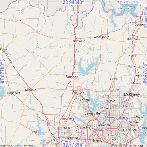
Sanger GPS coordinates[2]
33° 21' 47.412" North, 97° 10' 26.04" West
| Map corner | latitude | longitude |
|---|---|---|
| Upper-left | 33.94843°, | -97.87703° |
| Center: | 33.36317°, | -97.1739° |
| Lower-right: | 32.77394°, | -96.47078° |
| Map W x H: | 130.6×130.6 km | = 81.2×81.2mi |
| max Lat: | 71.29058° ⇑83.7% North |
| Sanger: | 33.36317° |
| min Lat: | ⇓16.3% South 19.06759° |
| min Long | Sanger | max Long |
| -171.73463° | -97.1739° | -66.98998° |
| W 23.8%⇐ | ⇒76.2% E |
Elevation
Elevation of Sanger is 209 m = 686 ft, and this is 85.8 m = 281 ft below average elevation for this country.
| Max E: |
3189 m = 10463 ft | 47.2% |
| Avg. | 294.8 m = 967 ft | |
| Sanger | 209 m = 686 ft | |
Min E: |
-60 m = -197 ft | 52.8% |
See also: United States elevation on elevation.city.
Geographical zone
Sanger is located in North temperate zone (between Tropic of Cancer and the Arctic Circle). Distance of this Northern Tropic circle is 1103.7 km =685.8 mi to South.| Distance of | km | miles | from Sanger |
|---|---|---|---|
| North Pole | 6297.4 | 3913 | to North |
| Arctic Circle | 3691.5 | 2293.8 | to North |
| Tropic Cancer | 1103.7 | 685.8 | to South |
| Equator | 3709.6 | 2305 | to South |


Nearby cities:
15 places around Sanger: (largest is in red/bold)
• Aubrey
18.6 km =11.6 mi,  110°
110°
• Corinth
25.4 km =15.8 mi,  156°
156°
• Cross Roads
21.7 km =13.5 mi,  132°
132°
• Denton
16.9 km =10.5 mi,  167°
167°
• Krugerville
19.3 km =12 mi,  118°
118°
• Krum
12.8 km =8 mi,  207°
207°
• New Hope (historical)
22.4 km =13.9 mi, 129°
• Oak Point
25.6 km =15.9 mi,  138°
138°
• Paloma Creek
26.8 km =16.7 mi, 124°
• Pilot Point
20.2 km =12.6 mi,  79°
79°
• Ponder
22.6 km =14 mi, 207°
• Providence
24.4 km =15.2 mi, 126°
• Shady Shores
25.8 km =16 mi,  148°
148°
• Tioga
26.4 km =16.4 mi,  64°
64°
• Valley View
13.9 km =8.6 mi,  3°
3°
Sources, notices
• [Note1] Compared only with cities in United States existing in our database
• [Src1] Map data: © OpenStreetMap contributors (CC-BY-SA)
• [Src2] Other city data from geonames.org with taken over terms of usage.
• [Src3] Geographical zone / Annual Mean Temperature by Robert A. Rohde @ Wikipedia
