Savoy geodata
Savoy (Texas) is a populated place; located in United States in America/Chicago (GMT-5) time zone. With population of 825 people, there are 17571 cities with bigger population in this country. Compared to other cities in United States, 82.7% of cities are located further ↑North; 74.1% of cities are located further →East and 53.2% of cities have lower elevation than Savoy. Note1


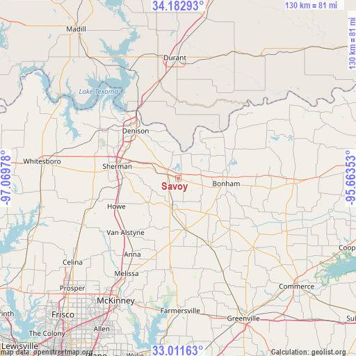
Savoy GPS coordinates[2]
33° 35' 57.372" North, 96° 21' 59.94" West
| Map corner | latitude | longitude |
|---|---|---|
| Upper-left | 34.18293°, | -97.06978° |
| Center: | 33.59927°, | -96.36665° |
| Lower-right: | 33.01163°, | -95.66353° |
| Map W x H: | 130.2×130.2 km | = 80.9×80.9mi |
| max Lat: | 71.29058° ⇑82.7% North |
| Savoy: | 33.59927° |
| min Lat: | ⇓17.3% South 19.06759° |
| min Long | Savoy | max Long |
| -171.73463° | -96.36665° | -66.98998° |
| W 25.9%⇐ | ⇒74.1% E |
Elevation
Elevation of Savoy is 211 m = 692 ft, and this is 83.8 m = 275 ft below average elevation for this country.
| Max E: |
3189 m = 10463 ft | 46.8% |
| Avg. | 294.8 m = 967 ft | |
| Savoy | 211 m = 692 ft | |
Min E: |
-60 m = -197 ft | 53.2% |
See also: United States elevation on elevation.city.
Geographical zone
Savoy is located in North temperate zone (between Tropic of Cancer and the Arctic Circle). Distance of this Northern Tropic circle is 1130 km =702.1 mi to South.| Distance of | km | miles | from Savoy |
|---|---|---|---|
| North Pole | 6271.2 | 3896.7 | to North |
| Arctic Circle | 3665.3 | 2277.5 | to North |
| Tropic Cancer | 1130 | 702.1 | to South |
| Equator | 3735.9 | 2321.4 | to South |


Nearby cities:
15 places around Savoy: (largest is in red/bold)
• Achille
26.1 km =16.2 mi,  355°
355°
• Bells
4.3 km =2.7 mi,  286°
286°
• Bonham
17.6 km =10.9 mi,  97°
97°
• Colbert
30.9 km =19.2 mi,  336°
336°
• Denison
23.4 km =14.5 mi,  317°
317°
• Ector
9 km =5.6 mi,  105°
105°
• Howe
24.9 km =15.5 mi,  246°
246°
• Leonard
26.8 km =16.7 mi,  155°
155°
• Luella
17.4 km =10.8 mi,  259°
259°
• Sherman
22.8 km =14.2 mi,  280°
280°
• Tom Bean
14 km =8.7 mi,  230°
230°
• Trenton
18.9 km =11.7 mi,  172°
172°
• Van Alstyne
27.8 km =17.3 mi,  224°
224°
• Westminster
27.8 km =17.3 mi,  198°
198°
• Whitewright
9.9 km =6.2 mi,  193°
193°
Sources, notices
• [Note1] Compared only with cities in United States existing in our database
• [Src1] Map data: © OpenStreetMap contributors (CC-BY-SA)
• [Src2] Other city data from geonames.org with taken over terms of usage.
• [Src3] Geographical zone / Annual Mean Temperature by Robert A. Rohde @ Wikipedia
