Sherman geodata
Sherman (Texas) is a seat of a second-order administrative division; located in United States in America/Chicago (GMT-5) time zone. With population of 40,667 people, there are 1189 cities with bigger population in this country. Compared to other cities in United States, 82.4% of cities are located further ↑North; 74.7% of cities are located further →East and 58.2% of cities have lower elevation than Sherman. Note1


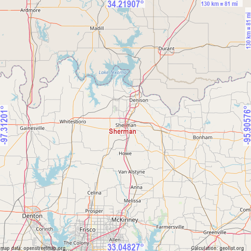
Sherman GPS coordinates[2]
33° 38' 8.376" North, 96° 36' 31.968" West
| Map corner | latitude | longitude |
|---|---|---|
| Upper-left | 34.21907°, | -97.31201° |
| Center: | 33.63566°, | -96.60888° |
| Lower-right: | 33.04827°, | -95.90576° |
| Map W x H: | 130.2×130.2 km | = 80.9×80.9mi |
| max Lat: | 71.29058° ⇑82.4% North |
| Sherman: | 33.63566° |
| min Lat: | ⇓17.6% South 19.06759° |
| min Long | Sherman | max Long |
| -171.73463° | -96.60888° | -66.98998° |
| W 25.3%⇐ | ⇒74.7% E |
Elevation
Elevation of Sherman is 231 m = 758 ft, and this is 63.8 m = 209 ft below average elevation for this country.
| Max E: |
3189 m = 10463 ft | 41.8% |
| Avg. | 294.8 m = 967 ft | |
| Sherman | 231 m = 758 ft | |
Min E: |
-60 m = -197 ft | 58.2% |
See also: Sherman elevation on elevation.city.
Geographical zone
Sherman is located in North temperate zone (between Tropic of Cancer and the Arctic Circle). Distance of this Northern Tropic circle is 1134 km =704.6 mi to South.| Distance of | km | miles | from Sherman |
|---|---|---|---|
| North Pole | 6267.1 | 3894.2 | to North |
| Arctic Circle | 3661.2 | 2275 | to North |
| Tropic Cancer | 1134 | 704.6 | to South |
| Equator | 3739.9 | 2323.9 | to South |


Nearby cities:
15 places around Sherman: (largest is in red/bold)
• Bells
18.6 km =11.6 mi,  98°
98°
• Cartwright
24.5 km =15.2 mi,  10°
10°
• Colbert
26.1 km =16.2 mi,  22°
22°
• Denison
14.9 km =9.3 mi,  26°
26°
• Gunter
24.5 km =15.2 mi,  211°
211°
• Howe
14.1 km =8.8 mi,  181°
181°
• Luella
9.1 km =5.7 mi,  143°
143°
• Pottsboro
14.8 km =9.2 mi,  337°
337°
• Preston
27.5 km =17.1 mi,  355°
355°
• Savoy
22.8 km =14.2 mi, 100°
• Southmayd
14.8 km =9.2 mi,  267°
267°
• Tom Bean
17.3 km =10.7 mi, 137°
• Van Alstyne
24 km =14.9 mi,  172°
172°
• Whitesboro
27.7 km =17.2 mi, 274°
• Whitewright
24.3 km =15.1 mi,  124°
124°
Sources, notices
• [Note1] Compared only with cities in United States existing in our database
• [Src1] Map data: © OpenStreetMap contributors (CC-BY-SA)
• [Src2] Other city data from geonames.org with taken over terms of usage.
• [Src3] Geographical zone / Annual Mean Temperature by Robert A. Rohde @ Wikipedia
