Achille geodata
Achille (Oklahoma) is a populated place; located in United States in America/Chicago (GMT-5) time zone. With population of 510 people, there are 20757 cities with bigger population in this country. Compared to other cities in United States, 81.3% of cities are located further ↑North; 74.2% of cities are located further →East and 52.2% of cities have lower elevation than Achille. Note1


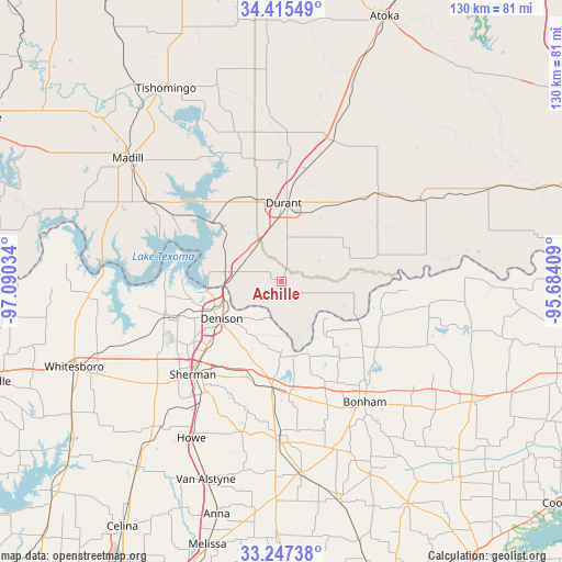
Achille GPS coordinates[2]
33° 50' 0.348" North, 96° 23' 13.956" West
| Map corner | latitude | longitude |
|---|---|---|
| Upper-left | 34.41549°, | -97.09034° |
| Center: | 33.83343°, | -96.38721° |
| Lower-right: | 33.24738°, | -95.68409° |
| Map W x H: | 129.9×129.9 km | = 80.7×80.7mi |
| max Lat: | 71.29058° ⇑81.3% North |
| Achille: | 33.83343° |
| min Lat: | ⇓18.7% South 19.06759° |
| min Long | Achille | max Long |
| -171.73463° | -96.38721° | -66.98998° |
| W 25.8%⇐ | ⇒74.2% E |
Elevation
Elevation of Achille is 207 m = 679 ft, and this is 87.8 m = 288 ft below average elevation for this country.
| Max E: |
3189 m = 10463 ft | 47.8% |
| Avg. | 294.8 m = 967 ft | |
| Achille | 207 m = 679 ft | |
Min E: |
-60 m = -197 ft | 52.2% |
See also: United States elevation on elevation.city.
Geographical zone
Achille is located in North temperate zone (between Tropic of Cancer and the Arctic Circle). Distance of this Northern Tropic circle is 1156 km =718.3 mi to South.| Distance of | km | miles | from Achille |
|---|---|---|---|
| North Pole | 6245.1 | 3880.5 | to North |
| Arctic Circle | 3639.2 | 2261.3 | to North |
| Tropic Cancer | 1156 | 718.3 | to South |
| Equator | 3761.9 | 2337.5 | to South |


Nearby cities:
15 places around Achille: (largest is in red/bold)
• Bells
24.9 km =15.5 mi,  185°
185°
• Bokchito
30.4 km =18.9 mi,  47°
47°
• Bonham
34.4 km =21.4 mi,  145°
145°
• Caddo
34.6 km =21.5 mi,  19°
19°
• Calera
11.9 km =7.4 mi,  341°
341°
• Cartwright
16.3 km =10.1 mi,  277°
277°
• Colbert
10.9 km =6.8 mi, 281°
• Denison
16.3 km =10.1 mi,  237°
237°
• Durant
17.9 km =11.1 mi,  4°
4°
• Ector
30.4 km =18.9 mi,  159°
159°
• Luella
33 km =20.5 mi,  207°
207°
• Pottsboro
27.4 km =17 mi,  252°
252°
• Preston
23.3 km =14.5 mi, 283°
• Savoy
26.1 km =16.2 mi,  175°
175°
• Sherman
30.1 km =18.7 mi,  222°
222°
Sources, notices
• [Note1] Compared only with cities in United States existing in our database
• [Src1] Map data: © OpenStreetMap contributors (CC-BY-SA)
• [Src2] Other city data from geonames.org with taken over terms of usage.
• [Src3] Geographical zone / Annual Mean Temperature by Robert A. Rohde @ Wikipedia
