Denison geodata
Denison (Texas) is a populated place; located in United States in America/Chicago (GMT-5) time zone. With population of 23,150 people, there are 2174 cities with bigger population in this country. Compared to other cities in United States, 81.8% of cities are located further ↑North; 74.5% of cities are located further →East and 57.2% of cities have lower elevation than Denison. Note1


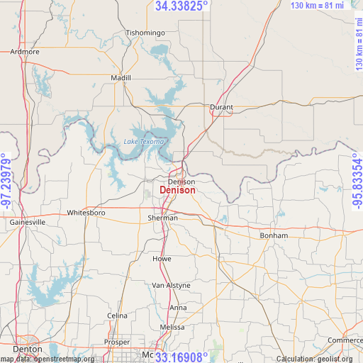
Denison GPS coordinates[2]
33° 45' 20.376" North, 96° 32' 11.976" West
| Map corner | latitude | longitude |
|---|---|---|
| Upper-left | 34.33825°, | -97.23979° |
| Center: | 33.75566°, | -96.53666° |
| Lower-right: | 33.16908°, | -95.83354° |
| Map W x H: | 130×130 km | = 80.8×80.8mi |
| max Lat: | 71.29058° ⇑81.8% North |
| Denison: | 33.75566° |
| min Lat: | ⇓18.2% South 19.06759° |
| min Long | Denison | max Long |
| -171.73463° | -96.53666° | -66.98998° |
| W 25.5%⇐ | ⇒74.5% E |
Elevation
Elevation of Denison is 227 m = 745 ft, and this is 67.8 m = 222 ft below average elevation for this country.
| Max E: |
3189 m = 10463 ft | 42.8% |
| Avg. | 294.8 m = 967 ft | |
| Denison | 227 m = 745 ft | |
Min E: |
-60 m = -197 ft | 57.2% |
See also: United States elevation on elevation.city.
Geographical zone
Denison is located in North temperate zone (between Tropic of Cancer and the Arctic Circle). Distance of this Northern Tropic circle is 1147.4 km =713 mi to South.| Distance of | km | miles | from Denison |
|---|---|---|---|
| North Pole | 6253.8 | 3885.9 | to North |
| Arctic Circle | 3647.9 | 2266.7 | to North |
| Tropic Cancer | 1147.4 | 713 | to South |
| Equator | 3753.3 | 2332.2 | to South |


Nearby cities:
15 places around Denison: (largest is in red/bold)
• Achille
16.3 km =10.1 mi,  57°
57°
• Bells
19.9 km =12.4 mi,  144°
144°
• Calera
22.3 km =13.9 mi,  26°
26°
• Cartwright
11.1 km =6.9 mi,  347°
347°
• Colbert
11.3 km =7 mi,  16°
16°
• Howe
28.3 km =17.6 mi,  194°
194°
• Luella
20.7 km =12.9 mi,  183°
183°
• Pottsboro
12.3 km =7.6 mi,  271°
271°
• Preston
16.7 km =10.4 mi,  327°
327°
• Savoy
23.4 km =14.5 mi, 137°
• Sherman
14.9 km =9.3 mi,  206°
206°
• Sherwood Shores
28.1 km =17.5 mi,  292°
292°
• Southmayd
25.6 km =15.9 mi,  237°
237°
• Tom Bean
26.6 km =16.5 mi,  169°
169°
• Whitewright
30.1 km =18.7 mi,  153°
153°
Sources, notices
• [Note1] Compared only with cities in United States existing in our database
• [Src1] Map data: © OpenStreetMap contributors (CC-BY-SA)
• [Src2] Other city data from geonames.org with taken over terms of usage.
• [Src3] Geographical zone / Annual Mean Temperature by Robert A. Rohde @ Wikipedia
