Brookneal geodata
Brookneal (Virginia) is a populated place; located in United States in America/New_York (GMT-4) time zone. With population of 1,119 people, there are 15571 cities with bigger population in this country. Compared to other cities in United States, 65.9% of cities are located further ↑North; 75.8% of cities are located further ←West and 57.5% of cities have higher elevation than Brookneal. Note1


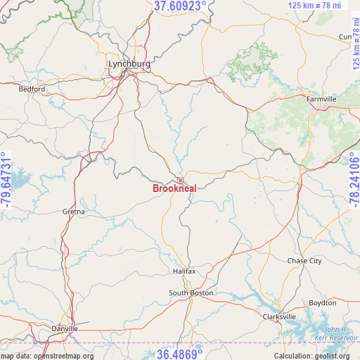
Brookneal GPS coordinates[2]
37° 3' 0.504" North, 78° 56' 39.048" West
| Map corner | latitude | longitude |
|---|---|---|
| Upper-left | 37.60923°, | -79.64731° |
| Center: | 37.05014°, | -78.94418° |
| Lower-right: | 36.4869°, | -78.24106° |
| Map W x H: | 124.8×124.8 km | = 77.5×77.5mi |
| max Lat: | 71.29058° ⇑65.9% North |
| Brookneal: | 37.05014° |
| min Lat: | ⇓34.1% South 19.06759° |
| min Long | Brookneal | max Long |
| -171.73463° | -78.94418° | -66.98998° |
| W 75.8%⇐ | ⇒24.2% E |
Elevation
Elevation of Brookneal is 168 m = 551 ft, and this is 126.8 m = 416 ft below average elevation for this country.
| Max E: |
3189 m = 10463 ft | 57.5% |
| Avg. | 294.8 m = 967 ft | |
| Brookneal | 168 m = 551 ft | |
Min E: |
-60 m = -197 ft | 42.5% |
See also: United States elevation on elevation.city.
Geographical zone
Brookneal is located in North temperate zone (between Tropic of Cancer and the Arctic Circle). Distance of this Northern Tropic circle is 1513.7 km =940.6 mi to South.| Distance of | km | miles | from Brookneal |
|---|---|---|---|
| North Pole | 5887.5 | 3658.3 | to North |
| Arctic Circle | 3281.6 | 2039.1 | to North |
| Tropic Cancer | 1513.7 | 940.6 | to South |
| Equator | 4119.6 | 2559.8 | to South |


Nearby cities:
15 places around Brookneal: (largest is in red/bold)
• Altavista
31.1 km =19.3 mi,  282°
282°
• Appomattox
35.7 km =22.2 mi,  17°
17°
• Charlotte Court House
27.1 km =16.8 mi,  88°
88°
• Concord
32.6 km =20.3 mi,  355°
355°
• Drakes Branch
31.1 km =19.3 mi,  101°
101°
• Gretna
38.4 km =23.9 mi,  253°
253°
• Halifax
31.6 km =19.6 mi,  177°
177°
• Hurt
31.6 km =19.6 mi, 278°
• Keysville
40.9 km =25.4 mi, 91°
• Motley
35.3 km =21.9 mi,  273°
273°
• Mountain Road
32.5 km =20.2 mi,  186°
186°
• Riverdale
40.5 km =25.2 mi,  174°
174°
• Rustburg
28.8 km =17.9 mi,  331°
331°
• South Boston
39.3 km =24.4 mi, 174°
• Timberlake
40.9 km =25.4 mi,  317°
317°
Sources, notices
• [Note1] Compared only with cities in United States existing in our database
• [Src1] Map data: © OpenStreetMap contributors (CC-BY-SA)
• [Src2] Other city data from geonames.org with taken over terms of usage.
• [Src3] Geographical zone / Annual Mean Temperature by Robert A. Rohde @ Wikipedia
