Charlotte Court House geodata
Charlotte Court House (Virginia) is a seat of a second-order administrative division; located in United States in America/New_York (GMT-4) time zone. With population of 530 people, there are 20501 cities with bigger population in this country. Compared to other cities in United States, 65.9% of cities are located further ↑North; 76.7% of cities are located further ←West and 54.5% of cities have higher elevation than Charlotte Court House. Note1


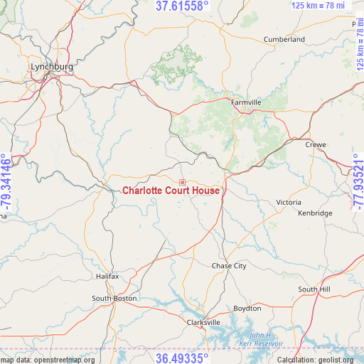
Charlotte Court House GPS coordinates[2]
37° 3' 23.544" North, 78° 38' 17.988" West
| Map corner | latitude | longitude |
|---|---|---|
| Upper-left | 37.61558°, | -79.34146° |
| Center: | 37.05654°, | -78.63833° |
| Lower-right: | 36.49335°, | -77.93521° |
| Map W x H: | 124.8×124.8 km | = 77.5×77.5mi |
| max Lat: | 71.29058° ⇑65.9% North |
| Charlotte Court House: | 37.05654° |
| min Lat: | ⇓34.1% South 19.06759° |
| min Long | Charlotte Court | max Long |
| -171.73463° | -78.63833° | -66.98998° |
| W 76.7%⇐ | ⇒23.3% E |
Elevation
Elevation of Charlotte Court House is 182 m = 597 ft, and this is 112.8 m = 370 ft below average elevation for this country.
| Max E: |
3189 m = 10463 ft | 54.5% |
| Avg. | 294.8 m = 967 ft | |
| Charlotte Court House | 182 m = 597 ft | |
Min E: |
-60 m = -197 ft | 45.5% |
See also: United States elevation on elevation.city.
Geographical zone
Charlotte Court House is located in North temperate zone (between Tropic of Cancer and the Arctic Circle). Distance of this Northern Tropic circle is 1514.4 km =941 mi to South.| Distance of | km | miles | from Charlotte Court House |
|---|---|---|---|
| North Pole | 5886.8 | 3657.9 | to North |
| Arctic Circle | 3280.9 | 2038.7 | to North |
| Tropic Cancer | 1514.4 | 941 | to South |
| Equator | 4120.3 | 2560.2 | to South |


Nearby cities:
15 places around Charlotte Court House: (largest is in red/bold)
• Appomattox
37.3 km =23.2 mi,  333°
333°
• Brookneal
27.1 km =16.8 mi,  268°
268°
• Chase City
32.8 km =20.4 mi,  150°
150°
• Concord
43.6 km =27.1 mi,  316°
316°
• Drakes Branch
7.8 km =4.8 mi, 154°
• Farmville
35 km =21.7 mi,  38°
38°
• Halifax
41.3 km =25.7 mi,  218°
218°
• Hampden Sydney
26 km =16.2 mi, 37°
• Kenbridge
46.8 km =29.1 mi,  102°
102°
• Keysville
13.9 km =8.6 mi, 97°
• Lunenburg
34.8 km =21.6 mi,  107°
107°
• Mountain Road
45.3 km =28.1 mi, 223°
• Riverdale
47.2 km =29.3 mi,  209°
209°
• South Boston
46.2 km =28.7 mi, 210°
• Victoria
37.1 km =23.1 mi, 100°
Sources, notices
• [Note1] Compared only with cities in United States existing in our database
• [Src1] Map data: © OpenStreetMap contributors (CC-BY-SA)
• [Src2] Other city data from geonames.org with taken over terms of usage.
• [Src3] Geographical zone / Annual Mean Temperature by Robert A. Rohde @ Wikipedia
