South Boston geodata
South Boston (Virginia) is a populated place; located in United States in America/New_York (GMT-4) time zone. With population of 7,976 people, there are 5291 cities with bigger population in this country. Compared to other cities in United States, 67.3% of cities are located further ↑North; 76% of cities are located further ←West and 66.2% of cities have higher elevation than South Boston. Note1


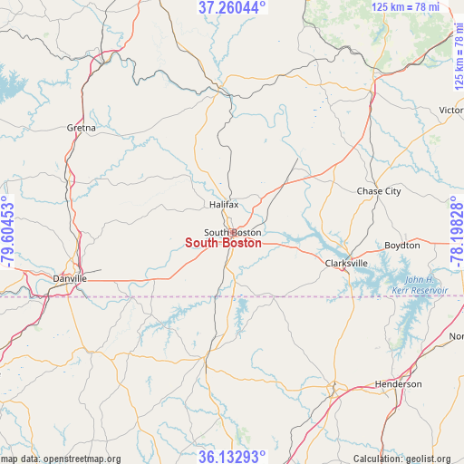
South Boston GPS coordinates[2]
36° 41' 55.5" North, 78° 54' 5.04" West
| Map corner | latitude | longitude |
|---|---|---|
| Upper-left | 37.26044°, | -79.60453° |
| Center: | 36.69875°, | -78.9014° |
| Lower-right: | 36.13293°, | -78.19828° |
| Map W x H: | 125.4×125.4 km | = 77.9×77.9mi |
| max Lat: | 71.29058° ⇑67.3% North |
| South Boston: | 36.69875° |
| min Lat: | ⇓32.7% South 19.06759° |
| min Long | South Boston | max Long |
| -171.73463° | -78.9014° | -66.98998° |
| W 76%⇐ | ⇒24% E |
Elevation
Elevation of South Boston is 122 m = 400 ft, and this is 172.8 m = 567 ft below average elevation for this country.
| Max E: |
3189 m = 10463 ft | 66.2% |
| Avg. | 294.8 m = 967 ft | |
| South Boston | 122 m = 400 ft | |
Min E: |
-60 m = -197 ft | 33.8% |
See also: United States elevation on elevation.city.
Geographical zone
South Boston is located in North temperate zone (between Tropic of Cancer and the Arctic Circle). Distance of this Northern Tropic circle is 1474.6 km =916.3 mi to South.| Distance of | km | miles | from South Boston |
|---|---|---|---|
| North Pole | 5926.5 | 3682.6 | to North |
| Arctic Circle | 3320.7 | 2063.4 | to North |
| Tropic Cancer | 1474.6 | 916.3 | to South |
| Equator | 4080.5 | 2535.5 | to South |


Nearby cities:
15 places around South Boston: (largest is in red/bold)
• Blairs
42.1 km =26.2 mi,  267°
267°
• Boydton
46 km =28.6 mi,  94°
94°
• Brookneal
39.3 km =24.4 mi,  354°
354°
• Charlotte Court House
46.2 km =28.7 mi,  30°
30°
• Chase City
41 km =25.5 mi,  74°
74°
• Chatham
46.4 km =28.8 mi,  287°
287°
• Clarksville
31.8 km =19.8 mi,  105°
105°
• Cluster Springs
8.8 km =5.5 mi,  191°
191°
• Danville
45.8 km =28.5 mi,  254°
254°
• Drakes Branch
42.2 km =26.2 mi,  39°
39°
• Halifax
7.9 km =4.9 mi,  342°
342°
• Mount Hermon
46.5 km =28.9 mi, 267°
• Mountain Road
10.2 km =6.3 mi,  311°
311°
• Riverdale
1.3 km =0.8 mi,  174°
174°
• Roxboro
34.7 km =21.6 mi, 192°
Sources, notices
• [Note1] Compared only with cities in United States existing in our database
• [Src1] Map data: © OpenStreetMap contributors (CC-BY-SA)
• [Src2] Other city data from geonames.org with taken over terms of usage.
• [Src3] Geographical zone / Annual Mean Temperature by Robert A. Rohde @ Wikipedia
